IMAGES TAKEN NEAR TO
Lime Kiln Court, BRISTOL, BS35 3AB
Introduction
This page details the photographs taken nearby to Lime Kiln Court, BS35 3AB by members of the Geograph project.
The Geograph project started in 2005 with the aim of publishing, organising and preserving representative images for every square kilometre of Great Britain, Ireland and the Isle of Man.

There are currently over 7.5m images from over14,400 individuals and you can help contribute to the project by visiting https://www.geograph.org.uk
Image Map
Images are licensed for reuse under creativecommons.org/licenses/by-sa/2.0
Notes
- Clicking on the map will re-center to the selected point.
- The higher the marker number, the further away the image location is from the centre of the postcode.
Image Listing (7 Images Found)
Images are licensed for reuse under creativecommons.org/licenses/by-sa/2.0
Image
Details
Distance
1
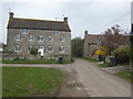
Hill Farm
The Itchington Road narrows to pass between these substantial buildings.
Image: © Jonathan Billinger
Taken: 30 Mar 2007
0.09 miles
2
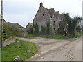
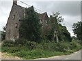
Derelict house at Manor Farm
Would be worth a fortune done up.
Image: © Jonathan Billinger
Taken: 30 Mar 2007
0.09 miles
4

South Gloucestershire : M5 Motorway
The M5 Motorway between Junction 15 (Almondsbury) and Junction 14 (Falfield).
Image: © Lewis Clarke
Taken: 30 Sep 2018
0.23 miles
5

M5 crosses Itchington road
At Marker 125.5
Image: © J.Hannan-Briggs
Taken: 30 Jul 2014
0.23 miles
6

Tytherington : M5 Motorway
The M5 Motorway between Junction 15 (Almondsbury) and Junction 14 (Falfield).
Image: © Lewis Clarke
Taken: 22 Sep 2019
0.24 miles
7
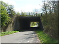
The M5 over Itchington Road
Close by the motorway is an older road, now an underpass. Some interesting geological features can be seen here - see Image
Image: © Neil Owen
Taken: 15 Apr 2021
0.24 miles