IMAGES TAKEN NEAR TO
Derwent Court, BRISTOL, BS35 2HW
Introduction
This page details the photographs taken nearby to Derwent Court, BS35 2HW by members of the Geograph project.
The Geograph project started in 2005 with the aim of publishing, organising and preserving representative images for every square kilometre of Great Britain, Ireland and the Isle of Man.

There are currently over 7.5m images from over14,400 individuals and you can help contribute to the project by visiting https://www.geograph.org.uk
Image Map
Images are licensed for reuse under creativecommons.org/licenses/by-sa/2.0
Notes
- Clicking on the map will re-center to the selected point.
- The higher the marker number, the further away the image location is from the centre of the postcode.
Image Listing (10 Images Found)
Images are licensed for reuse under creativecommons.org/licenses/by-sa/2.0
Image
Details
Distance
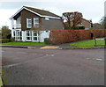
1
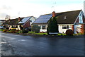
Solar panels, Shannon Court, Thornbury
Viewed from the edge of Grovesend Road.
Image: © Jaggery
Taken: 2 Jan 2012
0.05 miles
2
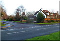
Corner of Malvern Drive and Grovesend Road, Thornbury
Viewed across Grovesend Road.
Image: © Jaggery
Taken: 2 Jan 2012
0.07 miles
3
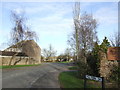
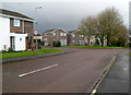
Malvern Drive
A quiet suburban road in Thornbury, a dormitary town for Bristol.
Image: © Jonathan Billinger
Taken: 15 Jan 2007
0.07 miles
4
Houses at the southern end of Sibland Road, Thornbury
Viewed across Grovesend Road.
Image: © Jaggery
Taken: 2 Jan 2012
0.13 miles
5
Chiltern Park houses, Thornbury
Viewed from near the Morton Way junction.
Chiltern Park is a cul-de-sac of about 40 houses at the SE edge of Thornbury.
Image: © Jaggery
Taken: 2 Jan 2012
0.13 miles
6
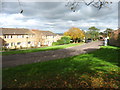
Houses in Avon Way, Thornbury
Many years ago, Thornbury changed from a small village to a commuter suburb of Bristol. This road in the south-east corner of the town is fairly typical.
Image: © David Purchase
Taken: 6 Nov 2016
0.15 miles
7
Eastern edge of Chiltern Park, Thornbury
Viewed from Morton Way. Chiltern Park is a cul-de-sac of about 40 houses at the SE edge of Thornbury.
Image: © Jaggery
Taken: 2 Jan 2012
0.17 miles
8
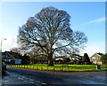
Tree dominates the northern end of Combermere, Thornbury
Now part of the eastern suburbs of Thornbury, the tree is a survivor
from the time when this area was all fields, as shown on a 1940s map.
Image: © Jaggery
Taken: 2 Jan 2012
0.19 miles
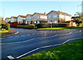
9
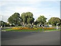
Roundabout southeast of Thornbury
Grovesend Road (to left and right) intersects with Morton Way, a modest ring road that contains Thornbury on its south and east sides.
Image: © Robin Stott
Taken: 20 Sep 2010
0.19 miles
10
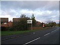
Midland Way
Midland Way acts as the southern boundary to Thornbury's housing estates, with houses backing onto it which front onto smaller roads and cul-de-sacs. This picture was taken from where the course of a dismantled railway crosses the road, though there are few clues to this left to see unless one compares the terrain with a detailed map.
Image: © Ruth Riddle
Taken: 17 Dec 2011
0.21 miles