IMAGES TAKEN NEAR TO
Oldbury Naite, Oldbury-on-Severn, BRISTOL, BS35 1RT
Introduction
This page details the photographs taken nearby to BS35 1RT by members of the Geograph project.
The Geograph project started in 2005 with the aim of publishing, organising and preserving representative images for every square kilometre of Great Britain, Ireland and the Isle of Man.

There are currently over 7.5m images from over14,400 individuals and you can help contribute to the project by visiting https://www.geograph.org.uk
Image Map (Loading...)


Getting Data...Please wait
Leaflet Map data © OpenStreetMap
Images are licensed for reuse under creativecommons.org/licenses/by-sa/2.0
Notes
- Clicking on the map will re-center to the selected point.
- The higher the marker number, the further away the image location is from the centre of the postcode.
Image Listing (10 Images Found)
Images are licensed for reuse under creativecommons.org/licenses/by-sa/2.0
Image
Details
Distance
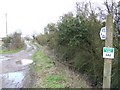
1
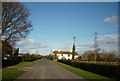
Lanes diverging
The junction where the track called Stoneyard Lane on the right of the picture leaves the through-route of Hill Lane on the left, with a gateway into the corner of the small triangular field that lies between the two roads.
Image: © Ruth Riddle
Taken: 28 Jan 2012
0.08 miles
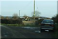
4
Stoneyard Lane
This bridleway heads east across the flat pastures of the Vale of Berkeley towards Rockhampton.
Image: © Jonathan Billinger
Taken: 15 Jan 2007
0.12 miles
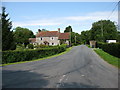
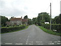
5

Hill Lane
Heading northeast towards the village of Hill.
Image: © Robin Stott
Taken: 27 Jul 2010
0.13 miles
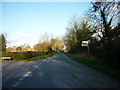
6
Shepperdine Lane
It heads northwest from the junction with the Naite and Hill Lane. A signpost behind the camera points to 'Shepperdine and the river' (an understatement) and 'Windbound Centre'. The latter is a residential care home for people with learning difficulties Image
Image: © Robin Stott
Taken: 27 Jul 2010
0.15 miles
7

Rhine by Stoneyard Lane
The drainage channel or rhine (pronounced 'reen') is fringed with common reed and creeping thistle.
Image: © Robin Stott
Taken: 27 Jul 2010
0.17 miles
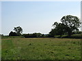
9

Fields by Stoneyard Lane
The grey hills in the distance are across the River Severn. The flat landscape bordering the river here is a mosaic of small irregular fields divided by drainage ditches or rhines (pronounced 'reens') and hedges alongside. The common trees are willow, oak and ash.
Image: © Robin Stott
Taken: 27 Jul 2010
0.24 miles