IMAGES TAKEN NEAR TO
Pullens Green, BRISTOL, BS35 1PW
Introduction
This page details the photographs taken nearby to Pullens Green, BS35 1PW by members of the Geograph project.
The Geograph project started in 2005 with the aim of publishing, organising and preserving representative images for every square kilometre of Great Britain, Ireland and the Isle of Man.

There are currently over 7.5m images from over14,400 individuals and you can help contribute to the project by visiting https://www.geograph.org.uk
Image Map
Images are licensed for reuse under creativecommons.org/licenses/by-sa/2.0
Notes
- Clicking on the map will re-center to the selected point.
- The higher the marker number, the further away the image location is from the centre of the postcode.
Image Listing (30 Images Found)
Images are licensed for reuse under creativecommons.org/licenses/by-sa/2.0
Image
Details
Distance
1
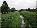
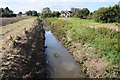
Oldbury Naite Rhine
Chapel Road on the left.
Image: © Jonathan Thacker
Taken: 15 Sep 2018
0.04 miles
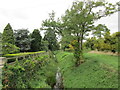
2
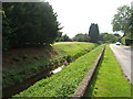
Rhine beside Chapel Road
The deep rhine beside Chapel Road has the capacity to hold a large volume of rainwater run-off from areas upstream, before it can be released into the River Severn, which can only occur when the tide is low.
Image: © Ruth Riddle
Taken: 28 Jul 2011
0.05 miles
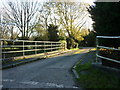
4
Footpath alongside Oldbury Naite Rhine
Image: © Jonathan Thacker
Taken: 15 Sep 2018
0.11 miles
5
Oldbury Pill
View to the west along Oldbury Pill towards the village of Oldbury-on-Severn.
Image: © Philip Halling
Taken: 29 Sep 2012
0.13 miles
6
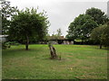
Sheds in an orchard
Both the sheds and the orchard have seen better days.
Image: © Jonathan Thacker
Taken: 15 Sep 2018
0.15 miles
7
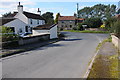
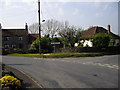
Cottages in Oldbury-on-Severn
Cottages on a road junction in Oldbury-on-Severn.
Image: © Philip Halling
Taken: 29 Sep 2012
0.15 miles
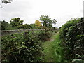
10
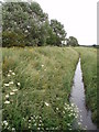
Stream headed for the Severn Estuary
This stream flows across the floodplain of the river Severn and eventually enters the Severn estuary at Oldbury Pill. In this view the stream channel runs alongside Pickedmoor lane. It is very straight and deep, obviously altered by man in an attempt to alleviate flood risk.
Image: © Sharon Loxton
Taken: 12 Jun 2006
0.17 miles