IMAGES TAKEN NEAR TO
Clover Road, BRISTOL, BS35 1AS
Introduction
This page details the photographs taken nearby to Clover Road, BS35 1AS by members of the Geograph project.
The Geograph project started in 2005 with the aim of publishing, organising and preserving representative images for every square kilometre of Great Britain, Ireland and the Isle of Man.

There are currently over 7.5m images from over14,400 individuals and you can help contribute to the project by visiting https://www.geograph.org.uk
Image Map (Loading...)


Getting Data...Please wait
Leaflet Map data © OpenStreetMap
Images are licensed for reuse under creativecommons.org/licenses/by-sa/2.0
Notes
- Clicking on the map will re-center to the selected point.
- The higher the marker number, the further away the image location is from the centre of the postcode.
Image Listing (6 Images Found)
Images are licensed for reuse under creativecommons.org/licenses/by-sa/2.0
Image
Details
Distance
1
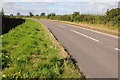
Oldbury Road
Oldbury Road which links Thornbury with Oldbury-on-Severn.
Image: © Philip Halling
Taken: 29 Sep 2012
0.14 miles
2
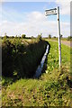
Footpath off Olbury Road
Sign to a footpath to Thornbury off Oldbury Road near Lower Morton.
Image: © Philip Halling
Taken: 29 Sep 2012
0.14 miles
3
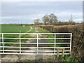
Footpath to Duckhole
The helpful contraption on the gate enables walkers to negotiate this path without having to open or climb the gate.
Image: © Jonathan Billinger
Taken: 15 Jan 2007
0.19 miles
4
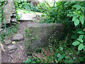
Stone Stile, Thornbury
On Gloucestershire footpath OTH/84 from a bridge over a stream looking towards Corn Rows. The view looking back towards the stream is Image
Image: © Mr Red
Taken: 17 May 2022
0.21 miles
5
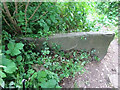
Stone Stile, Thornbury
On Gloucestershire footpath OTH/84 from a bridge over a stream looking towards the stream. The view looking back towards Corn Rows is Image
Image: © Mr Red
Taken: 17 May 2022
0.21 miles
6
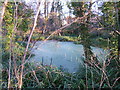
Thornbury Medieval Fishponds
Taken on a frosty New Year's Day 2010
Image: © Ruth Riddle
Taken: 1 Jan 2010
0.25 miles