IMAGES TAKEN NEAR TO
Castle Court, BRISTOL, BS34 8RF
Introduction
This page details the photographs taken nearby to Castle Court, BS34 8RF by members of the Geograph project.
The Geograph project started in 2005 with the aim of publishing, organising and preserving representative images for every square kilometre of Great Britain, Ireland and the Isle of Man.

There are currently over 7.5m images from over14,400 individuals and you can help contribute to the project by visiting https://www.geograph.org.uk
Image Map (Loading...)


Getting Data...Please wait
Leaflet Map data © OpenStreetMap
Images are licensed for reuse under creativecommons.org/licenses/by-sa/2.0
Notes
- Clicking on the map will re-center to the selected point.
- The higher the marker number, the further away the image location is from the centre of the postcode.
Image Listing (69 Images Found)
Images are licensed for reuse under creativecommons.org/licenses/by-sa/2.0
Image
Details
Distance
1
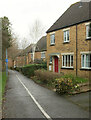
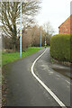
Community Forest Path, Stoke Gifford
Further north along the dual-use footpath LSG 10/50 from Image
Image: © Derek Harper
Taken: 3 Mar 2020
0.06 miles
2
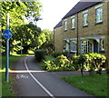
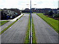
Segregated footpath and cycleway, Saint Way, Stoke Gifford
Cyclists on the left, walkers on the right
Image: © Jaggery
Taken: 4 Jun 2015
0.07 miles
3
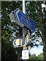
A popular post
Lots of advice and information, including what appears to be colour-coded cycle routes.
Image: © Neil Owen
Taken: 25 May 2019
0.10 miles
4
Community Forest Path, Stoke Gifford
A little further along footpath LSG 10/50 from Image
Image: © Derek Harper
Taken: 3 Mar 2020
0.10 miles
5
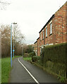
Community Forest Path, Stoke Gifford
Following footpath LSG 10/50. The houses on the right are on Sant Way.
Image: © Derek Harper
Taken: 3 Mar 2020
0.10 miles
6
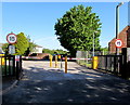
Private road - no thru traffic, Stoke Gifford
At the entrance to business premises on the north side of Pearsons Brick Yard Bridge. http://www.geograph.org.uk/photo/4509416
I was surprised to see the spelling THRU for THROUGH on the sign on the left.
Image: © Jaggery
Taken: 4 Jun 2015
0.12 miles
7
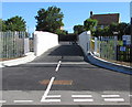
Bridge over railway lines north of Hambrook Lane, Stoke Gifford
Over railway lines 500 metres east of Bristol Parkway railway station.
The name on the bridge is Pearsons Brick Yard.
Image: © Jaggery
Taken: 4 Jun 2015
0.14 miles
8
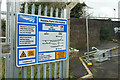
Railway Maintenance Access Point, Stoke Gifford
The corresponding notice to Image at the southern end of Pearsons Brick Yard Bridge; this is at the northern end, while at the southern end the site is named "Pugsley".
Image: © Derek Harper
Taken: 3 Mar 2020
0.14 miles
9
Looking south along Great Stoke Way
Taken from the footbridge looking south. At this time of day this road is extremely quiet (given its size), but I don't know what it is like at rush hour.
Image: © Linda Bailey
Taken: 8 Mar 2007
0.14 miles
10
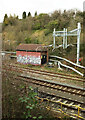
Stoke Gifford East Signal Box
In a cutting, seen from the Community Forest Path crossing Pearsons Brick Yard Bridge Image
Image: © Derek Harper
Taken: 3 Mar 2020
0.14 miles