IMAGES TAKEN NEAR TO
Foxglove Close, BRISTOL, BS34 8LH
Introduction
This page details the photographs taken nearby to Foxglove Close, BS34 8LH by members of the Geograph project.
The Geograph project started in 2005 with the aim of publishing, organising and preserving representative images for every square kilometre of Great Britain, Ireland and the Isle of Man.

There are currently over 7.5m images from over14,400 individuals and you can help contribute to the project by visiting https://www.geograph.org.uk
Image Map (Loading...)


Getting Data...Please wait
Leaflet Map data © OpenStreetMap
Images are licensed for reuse under creativecommons.org/licenses/by-sa/2.0
Notes
- Clicking on the map will re-center to the selected point.
- The higher the marker number, the further away the image location is from the centre of the postcode.
Image Listing (92 Images Found)
Images are licensed for reuse under creativecommons.org/licenses/by-sa/2.0
Image
Details
Distance
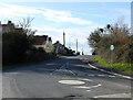
1
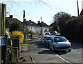
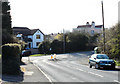
2011 : Northern end of Harry Stoke Road
Seen from the junction with Church Road and Hambrook Lane.
Image: © Maurice Pullin
Taken: 20 Mar 2011
0.03 miles
2
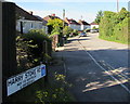
Northern end of Harry Stoke Road, Stoke Gifford
Looking south from the Church Road and Hambrook Lane junction.
Image: © Jaggery
Taken: 4 Jun 2015
0.06 miles
3
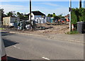
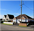
Church Road building site, Stoke Gifford
Viewed in early June 2015. An October 2008 Google Earth Street View shows a 2-storey house here.
Image: © Jaggery
Taken: 4 Jun 2015
0.09 miles
4
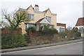
'Belmont', Church Road
There is an OS benchmark Image in the bricks of the right hand side gatepost at the stepped entrance to the house
Image: © Roger Templeman
Taken: 2 Mar 2013
0.10 miles
5
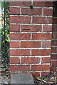
Benchmark on gatepost of 'Belmont', Church Road
Ordnance Survey cut mark benchmark described on the Bench Mark Database at http://www.bench-marks.org.uk/bm47469
Image: © Roger Templeman
Taken: 2 Mar 2013
0.10 miles
6
2011 : The junction of Church Road and Hambrook Lane
Harry Stoke Road to the left at the mini roundabout.
Image: © Maurice Pullin
Taken: 20 Mar 2011
0.11 miles
7
Wires over Church Road, Stoke Gifford
Although in effect a northern suburb of Bristol, Stoke Gifford is
in South Gloucestershire, beyond the County and City of Bristol.
Image: © Jaggery
Taken: 4 Jun 2015
0.11 miles
8
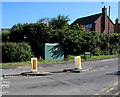
Hambrook Lane electricity substation, Stoke Gifford
The Western Power Distribution electricity substation is at the western end of Hambrook Lane,
near the roundabout at the Church Road and Harry Stoke Road junction.
Image: © Jaggery
Taken: 4 Jun 2015
0.11 miles
9

Future TV shop and vans in Stoke Gifford
Located in Parkway House, Hambrook Lane.
Image: © Jaggery
Taken: 4 Jun 2015
0.15 miles
10
2011 : Eastern end of Church Road, Stoke Gifford
The mini roundabout marks the junction of Church Road with Hambrook Lane to the right and Harry Stoke Road behind the camera.
Image: © Maurice Pullin
Taken: 20 Mar 2011
0.15 miles