IMAGES TAKEN NEAR TO
Charborough Road, BRISTOL, BS34 7RN
Introduction
This page details the photographs taken nearby to Charborough Road, BS34 7RN by members of the Geograph project.
The Geograph project started in 2005 with the aim of publishing, organising and preserving representative images for every square kilometre of Great Britain, Ireland and the Isle of Man.

There are currently over 7.5m images from over14,400 individuals and you can help contribute to the project by visiting https://www.geograph.org.uk
Image Map (Loading...)


Getting Data...Please wait
Leaflet Map data © OpenStreetMap
Images are licensed for reuse under creativecommons.org/licenses/by-sa/2.0
Notes
- Clicking on the map will re-center to the selected point.
- The higher the marker number, the further away the image location is from the centre of the postcode.
Image Listing (53 Images Found)
Images are licensed for reuse under creativecommons.org/licenses/by-sa/2.0
Image
Details
Distance
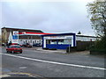
1
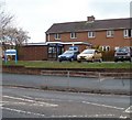
Filton Police Station
Located on Gloucester Road North, opposite Charborough Road. The police station is part of Avon and Somerset Constabulary. The constabulary has retained its name despite the abolition of the county of Avon in 1996. Filton is now in South Gloucestershire.
Image: © Jaggery
Taken: 6 Nov 2010
0.02 miles
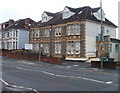
2
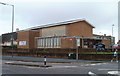
St Andrew's, Filton
Methodist Church and Youth Centre located on the corner of Gloucester Road North (A38) and Elm Park. The Youth Centre is in the church hall, behind the church, on Elm Park.
Image: © Jaggery
Taken: 6 Nov 2010
0.02 miles
3
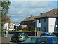
Gloucester Road North, Filton
Looking towards the Police Station from the Tesco garage.
Image: © Eirian Evans
Taken: 24 Oct 2010
0.04 miles
4
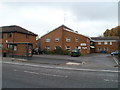
Sinclair House, Filton
Sheltered housing (flats) located at 64 Gloucester Road North.
Image: © Jaggery
Taken: 6 Nov 2010
0.05 miles
5
Tesco Express, Filton
73-75 Gloucester Road North. The shop is open from 6am to midnight daily.
Image: © Jaggery
Taken: 6 Nov 2010
0.05 miles
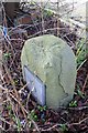
6

Old milestone (Bristol 3) at St Teresa's Church Hall
There is an Ordnance Survey cut mark benchmark on the stone just above current ground level. A detailed description of the mark is on the Bench Mark Database at http://www.bench-marks.org.uk/bm47457
Image: © Roger Templeman
Taken: 2 Mar 2013
0.06 miles
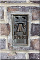
7
Old Milestone by the A38, Gloucester Road, Filton
Metal plate attached to stone post by the A38, in parish of Filton (South Gloucestershire District), Northeast corner of St. Teresa's churchyard, behind railings (on encroachment of private property), on West side of road. (Copy of) Bristol incised iron plate. Erected by the Bristol turnpike trust in the 19th century.
Inscription reads:-
To
Briſtol
(3)
South Gloucestershire HER.
HER number: 13932. https://www.heritagegateway.org.uk/Gateway/Results_Single.aspx?uid=13932&resourceID=111
Milestone Society National ID: GL_BRGL03
Image: © M Faherty
Taken: 20 Jul 2011
0.06 miles
8
Benchmark on buttress of St Teresa's Church Hall
Ordnance Survey flush bracket (serial number G2583) benchmark described on the Bench Mark Database at http://www.bench-marks.org.uk/bm14565
Image: © Roger Templeman
Taken: 2 Mar 2013
0.07 miles
9
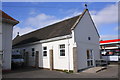
St Teresa's Church Hall
There is an OS flush bracket benchmark Image on the left side on the buttress on the near corner buttress
Image: © Roger Templeman
Taken: 2 Mar 2013
0.07 miles
10
The Priory Day Nursery, Filton
Located at 99 Gloucester Road North, opposite Springfields. Nursery with places for 42 children age 6 weeks to 5 years.
Image: © Jaggery
Taken: 6 Nov 2010
0.07 miles