IMAGES TAKEN NEAR TO
Northway, BRISTOL, BS34 7QG
Introduction
This page details the photographs taken nearby to Northway, BS34 7QG by members of the Geograph project.
The Geograph project started in 2005 with the aim of publishing, organising and preserving representative images for every square kilometre of Great Britain, Ireland and the Isle of Man.

There are currently over 7.5m images from over14,400 individuals and you can help contribute to the project by visiting https://www.geograph.org.uk
Image Map (Loading...)


Getting Data...Please wait
Leaflet Map data © OpenStreetMap
Images are licensed for reuse under creativecommons.org/licenses/by-sa/2.0
Notes
- Clicking on the map will re-center to the selected point.
- The higher the marker number, the further away the image location is from the centre of the postcode.
Image Listing (7 Images Found)
Images are licensed for reuse under creativecommons.org/licenses/by-sa/2.0
Image
Details
Distance

2
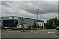
Filton : Belvedere Close
Looking towards Ceva on Belvedere Close.
Image: © Lewis Clarke
Taken: 11 Jul 2023
0.23 miles
3
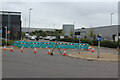
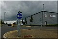
Diversion at roundabout on Bolingbroke Way
Horizon 38 Business Park; Titan Road comes in from the left.
Image: © M J Roscoe
Taken: 24 Aug 2022
0.23 miles
4
Filton : Titan Road
Looking along Titan Road.
Image: © Lewis Clarke
Taken: 11 Jul 2023
0.23 miles
5
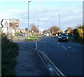
Junction of Gipsy Patch Lane and Station Road, Little Stoke
Viewed from the eastern side of the railway bridge. http://www.geograph.org.uk/photo/2156291
Ahead is Gipsy Patch Lane. Turn left into Station Road http://www.geograph.org.uk/photo/2156323 for Patchway railway station, the Civic Amenity Site, a health & leisure club, and Aretians Rugby Football Club.
Image: © Jaggery
Taken: 6 Nov 2010
0.23 miles
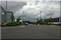
6
Filton : Bolingbroke Way
Looking across the roundabout.
Image: © Lewis Clarke
Taken: 11 Jul 2023
0.24 miles
7
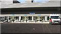
National Blood Service Centre
This shows where blood from donor sessions is received for processing.
Image: © Alan Hawkes
Taken: 12 Nov 2008
0.25 miles