IMAGES TAKEN NEAR TO
Redfield Road, BRISTOL, BS34 6PJ
Introduction
This page details the photographs taken nearby to Redfield Road, BS34 6PJ by members of the Geograph project.
The Geograph project started in 2005 with the aim of publishing, organising and preserving representative images for every square kilometre of Great Britain, Ireland and the Isle of Man.

There are currently over 7.5m images from over14,400 individuals and you can help contribute to the project by visiting https://www.geograph.org.uk
Image Map (Loading...)


Getting Data...Please wait
Leaflet Map data © OpenStreetMap
Images are licensed for reuse under creativecommons.org/licenses/by-sa/2.0
Notes
- Clicking on the map will re-center to the selected point.
- The higher the marker number, the further away the image location is from the centre of the postcode.
Image Listing (68 Images Found)
Images are licensed for reuse under creativecommons.org/licenses/by-sa/2.0
Image
Details
Distance
1
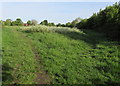
Track through Rolls-Royce land near Patchway railway station
A nearby sign states that this land is the private property of Rolls-Royce plc and that there is no public access except along public footpaths. Rolls-Royce plc hereby permits access by members of the public onto the land for recreational purposes. This permission may be revoked by Rolls-Royce plc at any time. Rolls-Royce plc shall be entitled to eject any person from the land at any time. The land is not maintained to the standards of a formal recreation ground and all persons coming onto the land do so at their own risk.
With these pronouncements in mind, I turned around here and left the private land.
Image: © Jaggery
Taken: 13 May 2015
0.09 miles
2
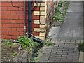
Ordnance Survey Cut Mark
This OS cut mark can be found on the old hall east side of the Gloucester Road. It marks a point 65.252m above mean sea level.
Image: © Adrian Dust
Taken: 24 Dec 2022
0.10 miles
4
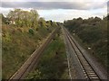
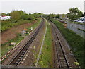
High level and low level lines towards Patchway railway station
Viewed from the A38 Gloucester Road. A cutting and an embankment are side by side. The line on the left was the original single-track line to Patchway railway station which opened nearby in 1863.
After the Severn Tunnel opened in 1886, so many trains brought coal from South Wales that the second track on the right had to be built. The new track was at a different level, so the station had to be moved further south to its present site out of shot ahead, where the lines are at the same level.
Image: © Jaggery
Taken: 13 May 2015
0.11 miles
5

Camera on Gloucester Road
Monitoring traffic on the A38 heading towards Bristol.
Image: © Bill Boaden
Taken: 10 Jul 2020
0.12 miles
6
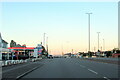
The A38 south passing the Esso Rontec garage
Image: © Roy Hughes
Taken: 9 Jul 2022
0.12 miles
7
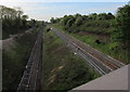
Railway towards Patchway Tunnel
Viewed from this http://www.geograph.org.uk/photo/4480460 footbridge. Because of the different track levels, the SE portals of Patchway Tunnel (out of shot ahead) are not side by side. The portal for the track on the left is about 250 metres behind the portal for the lower track.
Image: © Jaggery
Taken: 13 May 2015
0.12 miles
8
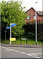
Signpost on a Little Stoke corner
On the corner of Station Road and Clay Lane.
The blue arms on the signpost show directions and distances for walkers and cyclists.
Image: © Jaggery
Taken: 13 May 2015
0.13 miles
9
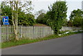
Signs at a railway perimeter fence, Station Road, Little Stoke
The signs show that Station Road ahead is a route to Patchway for walkers and cyclists,
but not for motor vehicles, for which the through route is the right turn into Clay Lane.
Image: © Jaggery
Taken: 13 May 2015
0.13 miles
10
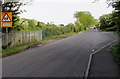
Warning sign - school nearby, Station Road, Little Stoke
A path from Station Road ahead leads to a primary school.
Image: © Jaggery
Taken: 13 May 2015
0.14 miles