IMAGES TAKEN NEAR TO
Station Road, BRISTOL, BS34 6LP
Introduction
This page details the photographs taken nearby to Station Road, BS34 6LP by members of the Geograph project.
The Geograph project started in 2005 with the aim of publishing, organising and preserving representative images for every square kilometre of Great Britain, Ireland and the Isle of Man.

There are currently over 7.5m images from over14,400 individuals and you can help contribute to the project by visiting https://www.geograph.org.uk
Image Map (Loading...)


Getting Data...Please wait
Leaflet Map data © OpenStreetMap
Images are licensed for reuse under creativecommons.org/licenses/by-sa/2.0
Notes
- Clicking on the map will re-center to the selected point.
- The higher the marker number, the further away the image location is from the centre of the postcode.
Image Listing (47 Images Found)
Images are licensed for reuse under creativecommons.org/licenses/by-sa/2.0
Image
Details
Distance
1
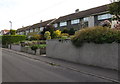
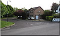
Station Road houses, Little Stoke
Near the site of the original http://www.geograph.org.uk/photo/4474488 Patchway railway station.
The present-day station is about 750 metres behind the camera.
Image: © Jaggery
Taken: 13 May 2015
0.02 miles
2
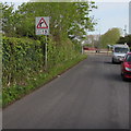
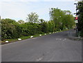
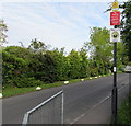
Maximum speed 15mph near the northern end of Station Road, Little Stoke
On the approach to a bend into Brookfield Road.
Image: © Jaggery
Taken: 13 May 2015
0.02 miles
3
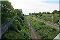
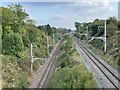
Railway towards Bristol Parkway
The tracks are separated having emerged from a tunnel not long previously.
Image: © Bill Boaden
Taken: 10 Jul 2020
0.03 miles
4
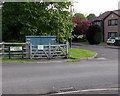
Station Road boulder marking the original location of Patchway railway station
An information board on the boulder records that the railway came to Patchway in 1863 as a single track line as far as Pilning. Patchway Station was just here. There was a weighbridge by the station to check that wagons were not overladen. The tall houses in Station Road were built for railway officials such as the station master.
After the Severn Tunnel opened in 1886, so many trains brought coal from South Wales that a second track had to be built. The new track was at a different level http://www.geograph.org.uk/photo/4474548 so the station had to be moved further south to its present site, about 750 metres away (and further away from Patchway), where the lines are at the same level.
Image: © Jaggery
Taken: 13 May 2015
0.04 miles
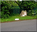
5
White painted rocks at the edge of Station Road, Little Stoke
Preventing vehicles parking on the grass.
Image: © Jaggery
Taken: 13 May 2015
0.05 miles
6
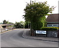
Corner of Station Road and Brookfield Road, Patchway
Brookfield Road on the left leads to The Sherrings.
The A38 Gloucester Road is at the left edge of the view, at a slightly lower level.
Image: © Jaggery
Taken: 13 May 2015
0.05 miles
7
Brookfield Road Pumping Station, Patchway
Wessex Water site.
Image: © Jaggery
Taken: 13 May 2015
0.05 miles
8
Patchway 1st railway station (site), Gloucestershire
Opened in 1863 by the Bristol & South Wales Union Railway, later part of the Great Western Railway, on the line from Bristol to New Passage (for ferry connections across the Bristol Channel). This station closed in 1885 when it was replaced by the current Patchway station. The line was diverted (and lowered here) into the new Severn Tunnel which opened in 1886, rendering the New Passage branch redundant.
View south east towards the replacement Patchway (out of sight around the curve) and Bristol. The first station was in the middle distance and was two parallel platforms, although the line to New Passage was just single track.
Image: © Nigel Thompson
Taken: 9 Oct 2021
0.06 miles
9
The Sherrings, Patchway
Cul-de-sac on the north side of Brookfield Road.
Image: © Jaggery
Taken: 13 May 2015
0.06 miles
10
Three notices on a Station Road lamppost, Little Stoke
In descending order are a CCTV camera notice, a Fly Tipping - See it Report It! notice
and a This is a Neighbourhood Watch Area notice.
Image: © Jaggery
Taken: 13 May 2015
0.06 miles