IMAGES TAKEN NEAR TO
Kingsway, BRISTOL, BS34 6JW
Introduction
This page details the photographs taken nearby to Kingsway, BS34 6JW by members of the Geograph project.
The Geograph project started in 2005 with the aim of publishing, organising and preserving representative images for every square kilometre of Great Britain, Ireland and the Isle of Man.

There are currently over 7.5m images from over14,400 individuals and you can help contribute to the project by visiting https://www.geograph.org.uk
Image Map (Loading...)


Getting Data...Please wait
Leaflet Map data © OpenStreetMap
Images are licensed for reuse under creativecommons.org/licenses/by-sa/2.0
Notes
- Clicking on the map will re-center to the selected point.
- The higher the marker number, the further away the image location is from the centre of the postcode.
Image Listing (69 Images Found)
Images are licensed for reuse under creativecommons.org/licenses/by-sa/2.0
Image
Details
Distance
1
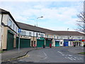
Row of shops, Little Stoke
Most of the shops in this row were closed because it was Sunday. The shops are on a roundabout in the south east corner of Little Stoke where Kingsway, Lawford Avenue and Gypsy Patch lane all meet. The services provided by the shops include: Beauty and Holistic Therapy, Post Office, Fish and Chip Shop, Pizza Shop, Hair Salon and a Newsagent and Convenience Store with an off licence.
Image: © Nigel Mykura
Taken: 17 Mar 2013
0.12 miles
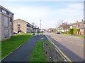
2
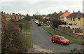
2012 : Rossall Avenue, Little Stoke, Bristol
Seen from Station Road, to which it is connected by footpath only, handy for Patchway Station.
One of Bristol's more pleasant suburbs.
Image: © Maurice Pullin
Taken: 16 Feb 2012
0.12 miles
3
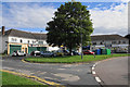
Row of shops in Little Stoke
Servicing a residential area.
Image: © Bill Boaden
Taken: 10 Jul 2020
0.12 miles
4
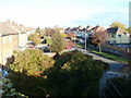
Rossall Avenue, Little Stoke
Viewed from the footbridge in Patchway railway station.
Image: © Jaggery
Taken: 6 Nov 2010
0.13 miles
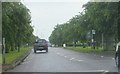
5
2012 : Station Road, Patchway, Bristol
Looking south toward Gipsy Patch Lane.
Patchway Railway Station is to the north, a few hundred yards behind the camera position.
Image: © Maurice Pullin
Taken: 16 Feb 2012
0.13 miles
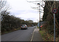
7
Bus stop beside the B4057
Looking eastwards along a rather rain-swept B4057 near Stoke Gifford, a bus stop and associated shelter which serve the westbound carriageway are seen to the right of the picture.
Image: © Ruth Riddle
Taken: 11 Jun 2012
0.15 miles
8
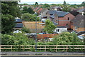
Back gardens, Rossall Avenue, Little Stoke
Back gardens and houses on the northern side of the Avenue; Station Road is in the foreground.
Image: © M J Roscoe
Taken: 24 Aug 2022
0.16 miles
9
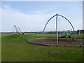
Little Stoke, adventure playground
In Little Stoke Park.
Image: © Mike Faherty
Taken: 29 Mar 2014
0.16 miles
10
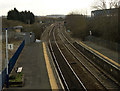
2012 : The main railway line from South Wales
Seen from the footbridge at Patchway Station as it heads south for Bristol Temple Meads, the branch east to Paddington is at the beginning of the next bend, almost opposite a single track line heads west then south to Avonmouth Docks.
Image: © Maurice Pullin
Taken: 16 Feb 2012
0.16 miles