IMAGES TAKEN NEAR TO
Blakeney Road, BRISTOL, BS34 5LT
Introduction
This page details the photographs taken nearby to Blakeney Road, BS34 5LT by members of the Geograph project.
The Geograph project started in 2005 with the aim of publishing, organising and preserving representative images for every square kilometre of Great Britain, Ireland and the Isle of Man.

There are currently over 7.5m images from over14,400 individuals and you can help contribute to the project by visiting https://www.geograph.org.uk
Image Map (37 Images)


Getting Data...Please wait
Leaflet Map data © OpenStreetMap
Images are licensed for reuse under creativecommons.org/licenses/by-sa/2.0
Notes
- Clicking on the map will re-center to the selected point.
- The higher the marker number, the further away the image location is from the centre of the postcode.
Image Listing (37 Images Found)
Images are licensed for reuse under creativecommons.org/licenses/by-sa/2.0
Image
Details
Distance
1
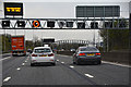
South Gloucestershire : The M5 Motorway
Looking along the M5 Motorway as it heads towards junction 15 and 16.
Image: © Lewis Clarke
Taken: 21 Apr 2016
0.07 miles
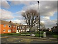
2
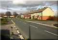
Coniston Road, Patchway
A terrace of 10 on the east side of the road.
Image: © Derek Harper
Taken: 22 Feb 2014
0.07 miles
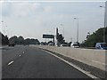
4
South Gloucestershire : The M5 Motorway
The motorway heads northbound through South Gloucestershire.
Image: © Lewis Clarke
Taken: 29 Oct 2013
0.12 miles
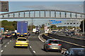
5

South Gloucestershire : The Severn Bridge
Looking out across from the M5 Motorway to the Severn Bridge.
Image: © Lewis Clarke
Taken: 1 Feb 2013
0.13 miles
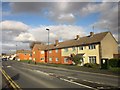
6
Bus stop, Coniston Road, Patchway
Currently served by the 75 and 625 services. The houses behind are on Arlingham Way.
Image: © Derek Harper
Taken: 22 Feb 2014
0.15 miles
7
Coniston Road, Patchway
The bus stop shown in Image] can be seen on the left.
Image: © Derek Harper
Taken: 22 Feb 2014
0.16 miles
8

Mini-roundabout, Patchway
At the junction of Stroud Road with Coniston Road.
Image: © Derek Harper
Taken: 22 Feb 2014
0.16 miles
9
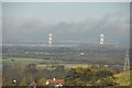
South Gloucestershire : The Severn Bridge
From the M5 Motorway looking out across fields and countryside towards the Severn Bridge.
Image: © Lewis Clarke
Taken: 1 Feb 2013
0.17 miles
10
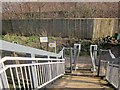
East end of motorway footbridge, Patchway
A squeeze stile to correspond with Image] at the other end. To the left, the Community Forest Path, following footpath OAY/53, runs alongside the M5 for about 200 metres to reach The Tumps. The other way, footpath OAY/53 turns right through the Patchway estate.
Image: © Derek Harper
Taken: 22 Feb 2014
0.18 miles