IMAGES TAKEN NEAR TO
Sycamore Drive, BRISTOL, BS34 5DH
Introduction
This page details the photographs taken nearby to Sycamore Drive, BS34 5DH by members of the Geograph project.
The Geograph project started in 2005 with the aim of publishing, organising and preserving representative images for every square kilometre of Great Britain, Ireland and the Isle of Man.

There are currently over 7.5m images from over14,400 individuals and you can help contribute to the project by visiting https://www.geograph.org.uk
Image Map (Loading...)


Getting Data...Please wait
Leaflet Map data © OpenStreetMap
Images are licensed for reuse under creativecommons.org/licenses/by-sa/2.0
Notes
- Clicking on the map will re-center to the selected point.
- The higher the marker number, the further away the image location is from the centre of the postcode.
Image Listing (18 Images Found)
Images are licensed for reuse under creativecommons.org/licenses/by-sa/2.0
Image
Details
Distance
1
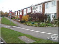
Birch Close houses, Patchway
Houses in this section of Birch Close are screened from Highwood Road by hedges and trees.
Image: © Jaggery
Taken: 6 Nov 2010
0.08 miles
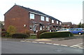
2
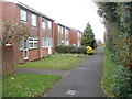
Coniston Road houses, Patchway
Houses viewed from the corner of Highwood Road.
Image: © Jaggery
Taken: 6 Nov 2010
0.11 miles
3
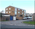
Cedar Close flats, Patchway
Viewed from the corner of Sycamore Drive.
Image: © Jaggery
Taken: 6 Nov 2010
0.11 miles
4
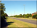
Road leading to The Mall
This dual carriageway is almost empty in this photograph but in the run up to Christmas this becomes a car-park as the area becomes grid-locked.
Image: © Linda Bailey
Taken: 18 Jul 2006
0.11 miles
5
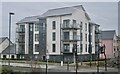
New apartments
Near Cribbs Causeway business park
Image: © Anthony O'Neil
Taken: 4 Feb 2023
0.13 miles
7
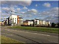
Estate Housing
Housing estate makes up most of the square.
Image: © Graham Richards
Taken: 15 Dec 2005
0.18 miles
8
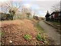
Highwood Lane
This section of Highwood Lane is closed to traffic. It follows a parish boundary and continues, for pedestrians and cyclists, the line of an old lane to the stone monolith roundabout. On the right are Highwood Pavilions, formerly government offices.
Image: © Derek Harper
Taken: 22 Feb 2014
0.20 miles
9
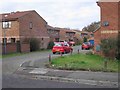
Bay Tree Close, Patchway
Houses viewed from the corner of Sycamore Drive.
Image: © Jaggery
Taken: 6 Nov 2010
0.20 miles
10
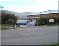
Entrance to Walkers Depot, Patchway
Viewed across Highwood Road. Walkers Snack Foods are best known for their crisps (potato chips in North American parlance).
Image: © Jaggery
Taken: 6 Nov 2010
0.21 miles