IMAGES TAKEN NEAR TO
South Liberty Lane, BRISTOL, BS3 2SJ
Introduction
This page details the photographs taken nearby to South Liberty Lane, BS3 2SJ by members of the Geograph project.
The Geograph project started in 2005 with the aim of publishing, organising and preserving representative images for every square kilometre of Great Britain, Ireland and the Isle of Man.

There are currently over 7.5m images from over14,400 individuals and you can help contribute to the project by visiting https://www.geograph.org.uk
Image Map
Images are licensed for reuse under creativecommons.org/licenses/by-sa/2.0
Notes
- Clicking on the map will re-center to the selected point.
- The higher the marker number, the further away the image location is from the centre of the postcode.
Image Listing (106 Images Found)
Images are licensed for reuse under creativecommons.org/licenses/by-sa/2.0
Image
Details
Distance
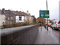
1

An ancient alleyway
The Batches were here well before most of the rest of the area - which grew after coal was mined.
Image: © Neil Owen
Taken: 17 Feb 2022
0.01 miles
2
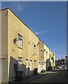
Alma Cottages, Bristol
A row of four terraced cottages on the southern fork of South Liberty Lane as it leads up to meet the A38, Bedminster Down Road.
Image: © Derek Harper
Taken: 15 Mar 2014
0.03 miles
3
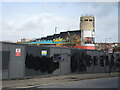
Changes by the old Odeon
The former cinema/bingo hall is now a climbing centre, with some arty pieces to go with it. A piece of land nearby is now boarded up for redevelopment. Pity the same artists were busy that day.
Image: © Neil Owen
Taken: 17 Feb 2022
0.04 miles
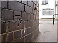
4
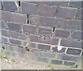
Ordnance Survey Cut Mark
This OS cut mark can be found on the NW parapet of the railway bridge on Bedminster Down Road. It marks a point 31.352m above mean sea level.
Image: © Adrian Dust
Taken: 13 Mar 2020
0.04 miles
5
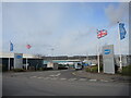
The entrance to Bailey's Caravans
The manufacturer has a large and busy site where the caravans are crafted. Originally this site was a clay pit and brickworks, before being filled in and becoming a builder's yard.
Image: © Neil Owen
Taken: 17 Feb 2022
0.05 miles
6
The A38 takes you both ways
Take your pick of west or south. A view from the brick-built railway bridge over the main southwest destinations. A benchmark is cut into the courses - see Image
Image: © Neil Owen
Taken: 19 Dec 2011
0.05 miles
7
Benchmark on the A38 bridge
The bricks are part of the railway bridge built in 1933 - the A38 road carries over the important tracks below. The cutmark is listed in the Benchmark Database: http://www.bench-marks.org.uk/bm40585 . See Image] for a broader view.
Image: © Neil Owen
Taken: 19 Dec 2011
0.05 miles
8
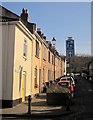
Nelson Street, Bedminster
A view up the "Victory Home Zone" shown in Image
Image: © Derek Harper
Taken: 15 Mar 2014
0.05 miles
9

Parson Street Station
Express train passing through Parson Street.
Image: © Wayland Smith
Taken: 2 Jun 2011
0.06 miles
10
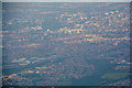
North Somerset : Bristol Scenery
Looking towards the City of Bristol from a plane which has left Bristol Airport.
Image: © Lewis Clarke
Taken: 9 Jun 2018
0.06 miles