IMAGES TAKEN NEAR TO
Hendre Road, BRISTOL, BS3 2LP
Introduction
This page details the photographs taken nearby to Hendre Road, BS3 2LP by members of the Geograph project.
The Geograph project started in 2005 with the aim of publishing, organising and preserving representative images for every square kilometre of Great Britain, Ireland and the Isle of Man.

There are currently over 7.5m images from over14,400 individuals and you can help contribute to the project by visiting https://www.geograph.org.uk
Image Map
Images are licensed for reuse under creativecommons.org/licenses/by-sa/2.0
Notes
- Clicking on the map will re-center to the selected point.
- The higher the marker number, the further away the image location is from the centre of the postcode.
Image Listing (47 Images Found)
Images are licensed for reuse under creativecommons.org/licenses/by-sa/2.0
Image
Details
Distance
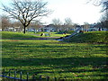
1
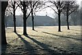
Gores Marsh Park
Currently a rather dull space with some trees and a play area, however looks like there are plans for improvements (quoted from link below):
"The Gores Marshalls formed in January 2008 to protect and improve this neglected green space. Local people have drawn up a plan including circular footpaths, signs, benches, new planting and an enclosed play and sports area.
The whole will cost around £250K, but stage one is to build a path rather than just have uneven and muddy grass. A small grant from the Better Bedminster Community Chest is a contribution towards this first step. Some other funding has already been secured and the Gores Marshalls are after more."
http://www.greaterbedminster.org.uk/news.php
Image: © MD
Taken: 7 Dec 2008
0.04 miles
2
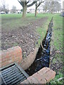
Draining the park
Gore's Marsh park is not named without reason. A modern drain allows excess water to disperse.
Image: © Neil Owen
Taken: 4 Mar 2022
0.05 miles
3
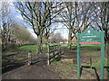
Gores Marsh Park
A public green space in Ashton for not that long. It was not until the early twentieth century that the park was an official site under the care of the council. Previously it was an unkempt area and (unsurprisingly) rather wet underfoot. Today it has a play area for children and some trees for landscaping, being registered as a village green since 1970.
Image: © Neil Owen
Taken: 4 Mar 2022
0.06 miles
4
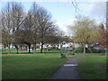
Gore's Marsh Park play area
Some exciting play equipment for the kids, including a zip wire, in the park. Several trees have been planted on what was until fairly recently a football pitch. No chance of a game now.
Image: © Neil Owen
Taken: 4 Mar 2022
0.08 miles
5
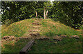
Mound, Gores Marsh Park
This must become an island in very wet weather, hence a series of (narrow) planks across the "moat".
Image: © Derek Harper
Taken: 1 Aug 2024
0.08 miles
6
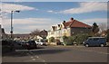
Bower Road, Bristol
The junction with Hendre Road (left) and Gore Road.
Image: © Derek Harper
Taken: 15 Mar 2014
0.08 miles
7
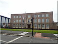
HMS Flying Fox, Winterstoke Road
This is the Bristol base of the Royal Navy Reserve. It trains over 100 reservists every week.
Image: © Eirian Evans
Taken: 9 Jun 2022
0.09 miles
9

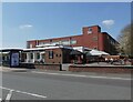
Blu skies
The side of the brick building reflects the bright sunlight. Formerly part of the tobacco factories of old, it is now transferred to vape products.
Image: © Neil Owen
Taken: 13 Feb 2023
0.11 miles
10
Gores Marsh Recreation Ground, Bedminster
Image: © Anthony O'Neil
Taken: 20 Jan 2011
0.12 miles