IMAGES TAKEN NEAR TO
Smyth Road, BRISTOL, BS3 2DP
Introduction
This page details the photographs taken nearby to Smyth Road, BS3 2DP by members of the Geograph project.
The Geograph project started in 2005 with the aim of publishing, organising and preserving representative images for every square kilometre of Great Britain, Ireland and the Isle of Man.

There are currently over 7.5m images from over14,400 individuals and you can help contribute to the project by visiting https://www.geograph.org.uk
Image Map
Images are licensed for reuse under creativecommons.org/licenses/by-sa/2.0
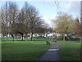
Notes
- Clicking on the map will re-center to the selected point.
- The higher the marker number, the further away the image location is from the centre of the postcode.
Image Listing (86 Images Found)
Images are licensed for reuse under creativecommons.org/licenses/by-sa/2.0
Image
Details
Distance
2
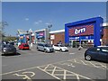
South Bristol retail park
Winterstoke Road used to be the home of the old Bristol buses depot, but it was cleared in the 1980s for this small retail park.
Image: © Neil Owen
Taken: 28 Apr 2014
0.07 miles
3
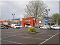
South Bristol Retail Park
A few well-known outlets here on the site of the old Bristol Bus depot.
Image: © Neil Owen
Taken: 14 Sep 2018
0.08 miles
4
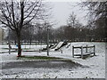
Gores Marsh covered
A late winter snow has given the children a chance to enjoy more natural pursuits.
Image: © Neil Owen
Taken: 8 Mar 2023
0.08 miles
5
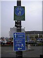
Share and share alike
A number of signs to guide the traveller, be they on foot or on wheels. However, the actual pavement doesn't seem to have any dividing line as most shared paths do.
Image: © Neil Owen
Taken: 9 Feb 2012
0.10 miles
6
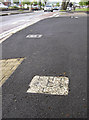
Winterstoke Road
The lower end of it as defined by an old boundary stone. See Image] for a better view.
Image: © Neil Owen
Taken: 28 Apr 2014
0.10 miles
7
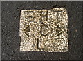
Dividing the land
A boundary marker stone, set into the pavement in Winterstoke Road. It must be of some importance as it seems to be made of granite; the City, Parliamentary, County and Municipal boundary was long-established but was moved in the twentieth century. This lower end of the road wasn't metalled until after WWI, but the marker has been spared resurfacing. See Image] for a broader view.
Image: © Neil Owen
Taken: 28 Apr 2014
0.10 miles
8
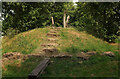
Mound, Gores Marsh Park
This must become an island in very wet weather, hence a series of (narrow) planks across the "moat".
Image: © Derek Harper
Taken: 1 Aug 2024
0.10 miles
9
Gore's Marsh Park play area
Some exciting play equipment for the kids, including a zip wire, in the park. Several trees have been planted on what was until fairly recently a football pitch. No chance of a game now.
Image: © Neil Owen
Taken: 4 Mar 2022
0.10 miles
10
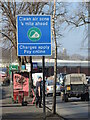
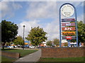
Clean air ahead
Or so you would think. Bristol's new pollution charging zone came into effect on Monday 28th November, 2022, so certain vehicles will be monitored and charged by cameras.
Image: © Neil Owen
Taken: 13 Feb 2023
0.10 miles