IMAGES TAKEN NEAR TO
High Street, BRISTOL, BS31 3EH
Introduction
This page details the photographs taken nearby to High Street, BS31 3EH by members of the Geograph project.
The Geograph project started in 2005 with the aim of publishing, organising and preserving representative images for every square kilometre of Great Britain, Ireland and the Isle of Man.

There are currently over 7.5m images from over14,400 individuals and you can help contribute to the project by visiting https://www.geograph.org.uk
Image Map
Images are licensed for reuse under creativecommons.org/licenses/by-sa/2.0
Notes
- Clicking on the map will re-center to the selected point.
- The higher the marker number, the further away the image location is from the centre of the postcode.
Image Listing (93 Images Found)
Images are licensed for reuse under creativecommons.org/licenses/by-sa/2.0
Image
Details
Distance
1
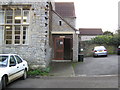
Church Hall
The big hall is useful for many things.
Image: © Class DE
Taken: 8 Nov 2006
0.01 miles
2
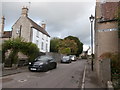
High St, Saltford
Saltford is one of those villages (near here, Chilcompton is another) which can seem to be just dull ribbon development on a main road, but which conceal an older heart, shown here, on a parallel road. Furthermore, the main railway line between Bath and Bristol passes through a short tunnel more or less underneath the photographer.
Image: © HelenK
Taken: 6 Sep 2019
0.02 miles
3
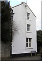
Collins Buildings
In about 1904 this was once a shop in the High Street, and was called “Coombes” The bottom window was then a small square bay window, and the entrance was on the far side.
Image: © Rick Crowley
Taken: 6 Mar 2010
0.02 miles
4
Saltford Manor
The Saltford Manor is thought to be the oldest continuously occupied private house in England, and has been designated as a Grade II listed building.
The original Norman construction was by William Fitz Robert, 2nd Earl of Gloucester, and was built on an estate owned at the time of the Domesday Book by Geoffrey de Montbray the Bishop of Coutances. It is contemporary with nearby Horton Court which was a prebendary house, therefore it is likely that Saltford had an association with Keynsham Abbey, and has long been associated with St Mary's Church in Saltford. (source Wikipedia)
Image: © Colin Park
Taken: 19 Oct 2021
0.04 miles
5
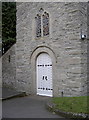
Tower entrance, St Mary's church, Saltford
The recently renovated tower of St Mary's, complete with a nicely painted door and a 1GL boltmark derived from a side levelling. See Image], and the database www.bench-marks.org.uk/bm36733
The church has been serving the local populace since Norman times and possibly earlier, and has historical links with the Battle of Lansdown (1643). See the church website http://www.stmaryssaltford.org.uk/index.html
Image: © Neil Owen
Taken: 29 Jan 2011
0.06 miles
6
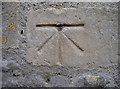
Bolt benchmark, St Mary's, Saltford
Bolt benchmark in the doorway of St Mary's church, Saltford. This building may date back to late Saxon times, but has certainly been renovated more than once since. Indeed the tower (in which this is beside the entrance) was worked on in 2009.
See Image] for a wider view.
The bolt is a 1GL, as listed in www.bench-marks.org.uk/bm36733
Image: © Neil Owen
Taken: 29 Jan 2011
0.06 miles
7
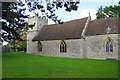
St Mary's Church, Saltford
A Grade II listed church with its roots from the Norman era, or possibly earlier.
Image: © Bill Boaden
Taken: 28 Sep 2017
0.06 miles
8

Saltford from the air
Looking along the railway line and the A4 towards Keynsham which can be seen in the distance. Viewed from a Bristol bound flight from Glasgow.
Image: © Thomas Nugent
Taken: 16 Aug 2011
0.06 miles

10
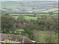
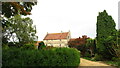
The view
This is a view of fields in Saltford.
Image: © Class DE
Taken: 8 Nov 2006
0.06 miles