IMAGES TAKEN NEAR TO
Queens Road, BRISTOL, BS31 2NE
Introduction
This page details the photographs taken nearby to Queens Road, BS31 2NE by members of the Geograph project.
The Geograph project started in 2005 with the aim of publishing, organising and preserving representative images for every square kilometre of Great Britain, Ireland and the Isle of Man.

There are currently over 7.5m images from over14,400 individuals and you can help contribute to the project by visiting https://www.geograph.org.uk
Image Map
Images are licensed for reuse under creativecommons.org/licenses/by-sa/2.0
Notes
- Clicking on the map will re-center to the selected point.
- The higher the marker number, the further away the image location is from the centre of the postcode.
Image Listing (13 Images Found)
Images are licensed for reuse under creativecommons.org/licenses/by-sa/2.0
Image
Details
Distance
1
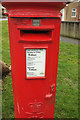
Postbox, Coronation Avenue, Keynsham
Elizabeth II postbox number BS31 400, at the corner of Park Road, is also shown in Image
Image: © Derek Harper
Taken: 10 Mar 2018
0.13 miles
2
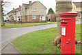
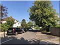
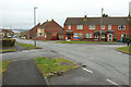
Coronation Avenue, Keynsham
At the junction with park Road. The Elizabeth II postbox is number BS31 400.
Image: © Derek Harper
Taken: 10 Mar 2018
0.14 miles
3
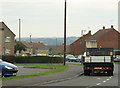
2010 : Coronation Avenue and view, Keynsham
Urban "development" south of Keynsham.
The council lorry waits, enjoying the view east of Bristol perhaps.
Image: © Maurice Pullin
Taken: 6 Sep 2010
0.19 miles
4
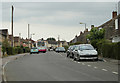
2010 : Suburban Keynsham
Coronation Avenue with a local First Direct bus. Service number 318, no destination board.
Shouldn't an avenue have trees?
A search of the internet reveals: 318: Keynsham - Cribbs Causeway
Via Kingswood, Staple Hill, Downend, Parkway
Image: © Maurice Pullin
Taken: 6 Sep 2010
0.20 miles
6
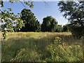
St Keyna's Wild Willow Wilderness
A haven for wildlife near Keynsham's primary school
Image: © Eirian Evans
Taken: 23 Aug 2021
0.21 miles
7
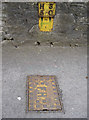
Old and new hydrant signs
Occasionally, older plates are still doing their duty, but here we have two for the price of one. Clearly, the older one is cast metal, the newer one enamel; modern versions tend to be plastic - and often self-adhesive at that.
Image: © Neil Owen
Taken: 30 Jan 2018
0.21 miles
8
St Keyna's Wild Willow Wilderness
Wildlife area near Keynsham's primary school
Image: © Eirian Evans
Taken: 23 Aug 2021
0.21 miles
9
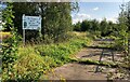
Coronation Avenue, Keynsham
At the junction with Dunster Road (right). The turning on the left leads into a group of garages.
Image: © Derek Harper
Taken: 10 Mar 2018
0.22 miles
10
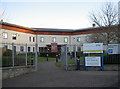
Where the poor and needy came
This modern (2007) complex is the new hospital, replacing the older buildings that were based on the old Keynsham Workhouse.
Once the Poor Law Union was established on 29th March 1836, a move to create a facility was quickly enacted. In the following year a design by William Armstrong who based it on Sampson Kempthorne's 'square' plan model. The cost was £4,960 and held up to 300 inmates. In 1903 a small detached infirmary block was added and thus began the medical history on this site.
Image: © Neil Owen
Taken: 30 Nov 2017
0.23 miles