IMAGES TAKEN NEAR TO
California Road, BRISTOL, BS30 9XH
Introduction
This page details the photographs taken nearby to California Road, BS30 9XH by members of the Geograph project.
The Geograph project started in 2005 with the aim of publishing, organising and preserving representative images for every square kilometre of Great Britain, Ireland and the Isle of Man.

There are currently over 7.5m images from over14,400 individuals and you can help contribute to the project by visiting https://www.geograph.org.uk
Image Map
Images are licensed for reuse under creativecommons.org/licenses/by-sa/2.0
Notes
- Clicking on the map will re-center to the selected point.
- The higher the marker number, the further away the image location is from the centre of the postcode.
Image Listing (23 Images Found)
Images are licensed for reuse under creativecommons.org/licenses/by-sa/2.0
Image
Details
Distance
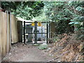
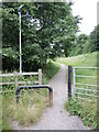
1
The path to the brook
Running off California Road and down to the Siston Brook.
Image: © Neil Owen
Taken: 19 Jun 2021
0.12 miles
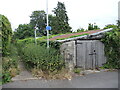
2
Cedar Close substation
There are some fairly appropriate trees lining the track to the unit.
Image: © Neil Owen
Taken: 19 Jun 2021
0.15 miles
3
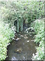
Siston Brook near California Road
The road takes its name form the disused California Colliery that operated nearby in the nineteenth century.
Image: © Neil Owen
Taken: 19 Jun 2021
0.17 miles
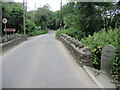
4
California Road bridge
The Siston Brook runs through what used to be the old California colliery.
Image: © Neil Owen
Taken: 19 Jun 2021
0.17 miles
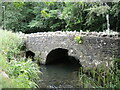
5
Down to the bridge
A small stone bridge spans the Siston Brook, a structure that has been here for well over a century despite the encroachment of modern housing.
Image: © Neil Owen
Taken: 19 Jun 2021
0.17 miles
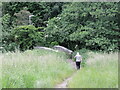
6
The path that follows the Siston Brook
Leaving Court Road, the path runs through the unbuilt valley of the brook. On the pole is a sticker relating the use of the walking bubble during the Covid era. See Image
Image: © Neil Owen
Taken: 19 Jun 2021
0.17 miles
7
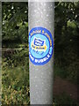
Walking bubble for school
A sticker on a post highlights the healthy way to school. See Image] for a wider view.
Image: © Neil Owen
Taken: 19 Jun 2021
0.17 miles
8
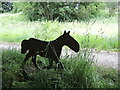
Iron horse by the Siston Brook
There are a few of these steel silhouettes around the area. Perhaps a nod to the old horse-drawn tracks that took the coal from the local pits to the barges.
Image: © Neil Owen
Taken: 19 Jun 2021
0.17 miles
9
Parish of Bitton stone
The Siston Brook forms a parish boundary, although it might be mistaken for a grave site.
Image: © Neil Owen
Taken: 19 Jun 2021
0.18 miles
10
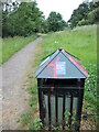
The Covid effect
Litter bins are not being emptied as frequently during the pandemic. Fortunately, this one seems to have capactiy.
Image: © Neil Owen
Taken: 19 Jun 2021
0.18 miles