IMAGES TAKEN NEAR TO
Long Beach Road, BRISTOL, BS30 9XD
Introduction
This page details the photographs taken nearby to Long Beach Road, BS30 9XD by members of the Geograph project.
The Geograph project started in 2005 with the aim of publishing, organising and preserving representative images for every square kilometre of Great Britain, Ireland and the Isle of Man.

There are currently over 7.5m images from over14,400 individuals and you can help contribute to the project by visiting https://www.geograph.org.uk
Image Map (Loading...)


Getting Data...Please wait
Leaflet Map data © OpenStreetMap
Images are licensed for reuse under creativecommons.org/licenses/by-sa/2.0
Notes
- Clicking on the map will re-center to the selected point.
- The higher the marker number, the further away the image location is from the centre of the postcode.
Image Listing (55 Images Found)
Images are licensed for reuse under creativecommons.org/licenses/by-sa/2.0
Image
Details
Distance
1
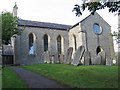
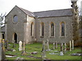
St Anne's Church, Oldland
Unusual round window in the south transept
Image: © William Avery
Taken: 23 Sep 2006
0.12 miles
2
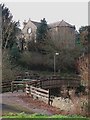
St Anne's Church and footbridge
St Anne's church stands at the head of the Willsbridge Valley, on the banks of Siston Brook (pronounced syes-ton).
Image: © Gordon James
Taken: 2 May 2004
0.12 miles
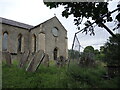
3
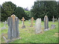
Graveyard of St Ann's
The church dates far back into the thirteenth century, occupying a spot on a hilltop overlooking the Siston Brook and in an area that was a hunting forest. Here the more modern graveyard still shows the steep drop to the brook.
Image: © Neil Owen
Taken: 19 Jun 2021
0.14 miles
4
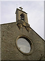
The bell of St Anne's
The exposed bell and oculus window (distinctive of this building) in the west end of the church.
Image: © Neil Owen
Taken: 16 Feb 2017
0.14 miles
5

West end of St Ann's church
The simple features of the west end of the church in Oldland. Originally there was a church of some description here since the thirteenth century; this version dates from 1830.
Image: © Neil Owen
Taken: 19 Jun 2021
0.14 miles
6
St Anne's in the Springtime
The snowdrops are now blooming in the churchyard.
Oldland was a small and inconspicuous hamlet on the Siston Brook for most of its history, but the nearby coalfields soon became a magnet for the population. The Industrial Revolution increased the demand and the village grew quickly. Up to that time it was under the jurisdiction of Bitton - some distance away - and this site, on a hilltop overlooking the valley, was a chapel of ease for some time.
St Anne's is a relatively new building; it was founded by Canon Ellacombe and opened for divine service on Sunday November 14th, 1830.
Image: © Neil Owen
Taken: 16 Feb 2017
0.15 miles
7

A sprinkle from the roof
A face with rather more holes than is strictly necessary, deposits rainwater far below.
Image: © Neil Owen
Taken: 19 Jun 2021
0.15 miles
8
Fencing at St Ann's
Work is being carried out on the large wall that forms the southeast boundary of the church. The site is a small hilltop and the retaining wall is having to hold a great weight of earth - including part of the graveyard.
Image: © Neil Owen
Taken: 19 Jun 2021
0.15 miles
9
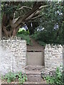
Stone stile to Oldland
The wall appears to have been rebuilt at some point, but the old stile has been retained.
Image: © Neil Owen
Taken: 19 Jun 2021
0.15 miles
10
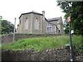
St Anne's on the hill
The church stands on a small but notable promontory, overlooking the Siston Brook.
Image: © Neil Owen
Taken: 19 Jun 2021
0.15 miles