IMAGES TAKEN NEAR TO
The Clamp, BRISTOL, BS30 9QF
Introduction
This page details the photographs taken nearby to The Clamp, BS30 9QF by members of the Geograph project.
The Geograph project started in 2005 with the aim of publishing, organising and preserving representative images for every square kilometre of Great Britain, Ireland and the Isle of Man.

There are currently over 7.5m images from over14,400 individuals and you can help contribute to the project by visiting https://www.geograph.org.uk
Image Map (Loading...)


Getting Data...Please wait
Leaflet Map data © OpenStreetMap
Images are licensed for reuse under creativecommons.org/licenses/by-sa/2.0
Notes
- Clicking on the map will re-center to the selected point.
- The higher the marker number, the further away the image location is from the centre of the postcode.
Image Listing (65 Images Found)
Images are licensed for reuse under creativecommons.org/licenses/by-sa/2.0
Image
Details
Distance
1
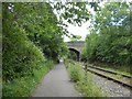
West Street bridge
Over the Bristol and Bath cycle path and Avon Valley Railway
Image: © David Smith
Taken: 10 Jun 2017
0.03 miles
2
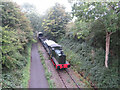
Avon Valley Railway near Oldland Common
Fry's Somerdale 4w Sentinel, No. 7492, approaches West Street bridge in Oldland Common on the Avon Valley Railway.
Image: © Gareth James
Taken: 16 Sep 2023
0.03 miles
3
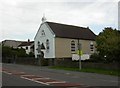
Oldland Common Tabernacle URC
On High Street. http://www.urc.org.uk/church/view?church_id=1913
Image: © Mike Faherty
Taken: 8 Oct 2010
0.03 miles
4
Avon Valley Railway near Oldland Common
Andrew Barclay 0-4-0DM No. WD824 Grumpy heads a goods service towards West Street bridge on the Avon Valley Railway.
Image: © Gareth James
Taken: 16 Sep 2023
0.03 miles
5
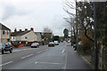
2011 : A4175 Oldland Common, heading south
Wikipedia http://en.wikipedia.org/wiki/Oldland_Common says "Oldland Common was first mentioned in the Domesday Book of 1086. As was common in the surrounding area, the village was involved in the coal mining industry and had its own pit on Cowhorn Hill during the 1800s."
They also tell us "Oldland Common is the birthplace of the famous astronomer Sir Bernard Lovell, and is home to the Sir Bernard Lovell secondary school, a designated language college opened by Lovell himself in 1972, once attended by England cricketer Marcus Trescothick."
Image: © Maurice Pullin
Taken: 17 Jan 2011
0.04 miles
6
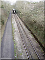
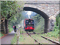
Off up to Oldland Station
The train passes under West Street bridge. Alongside the single track is a cycle path and, on the other side of it, a small stream. The track was originally part of the Midland branch line from Mangotsfield: it opened in 1865, became part of the LMS line later and finally closed to official traffic on 7th March, 1966. It is now a preserved railway.
Image: © Neil Owen
Taken: 16 Feb 2017
0.04 miles
7
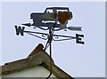
All roads and weathers
An unusual weathervane in Oldland, looking like some 4x4 offroader. See Image] for the wider view.
Image: © Neil Owen
Taken: 16 Feb 2017
0.04 miles
8
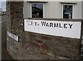
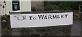
To Warmley
The other finger sign directing travellers (presumably on foot or horseback originally) to Warmley. See Image] for the wider view.
Image: © Neil Owen
Taken: 16 Feb 2017
0.04 miles
9
Old Guide Stone by the A4175, West Street, Oldland Common
Guide Stone by the A4175, in parish of Oldland (South Gloucestershire District), Oldland Common, junction of High Street with West Street, on top of wall, left hand side of entrance. Just West of Guide Stone: GL_BAFY07SR Image
Inscription reads:-
{<-hand} To WARMLEY
Surveyed
Milestone Society National ID: GL_BAFY07SL
Image: © Mike Faherty
Taken: 8 Oct 2010
0.04 miles
10
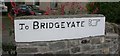
Old Guide Stone by the A4175, High Street, Oldland Common
Guide Stone by the A4175, in parish of Oldland (South Gloucestershire District), Oldland Common, junction of High Street with West Street on top of wall, right hand side of entrance. Just East of Guide Stone: GL_BAFY07SL Image
Inscription reads:-
To BRIDGEYATE {hand->}
Surveyed
Milestone Society National ID: GL_BAFY07SR
Image: © Mike Faherty
Taken: 8 Oct 2010
0.05 miles