IMAGES TAKEN NEAR TO
Station Road, BRISTOL, BS30 8XH
Introduction
This page details the photographs taken nearby to Station Road, BS30 8XH by members of the Geograph project.
The Geograph project started in 2005 with the aim of publishing, organising and preserving representative images for every square kilometre of Great Britain, Ireland and the Isle of Man.

There are currently over 7.5m images from over14,400 individuals and you can help contribute to the project by visiting https://www.geograph.org.uk
Image Map
Images are licensed for reuse under creativecommons.org/licenses/by-sa/2.0
Notes
- Clicking on the map will re-center to the selected point.
- The higher the marker number, the further away the image location is from the centre of the postcode.
Image Listing (53 Images Found)
Images are licensed for reuse under creativecommons.org/licenses/by-sa/2.0
Image
Details
Distance
1
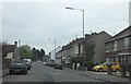
Housing in Station Road
Housing built in a variety of different eras lines Station Road in Warmley.
Image: © Ruth Riddle
Taken: 4 May 2012
0.00 miles
2
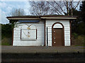
Refreshments kiosk at Warmley Station
A popular stopping point on the disused railway line which is now the Bristol-Bath cycle path.
Image: © Anthony O'Neil
Taken: 15 Mar 2011
0.05 miles
3
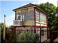
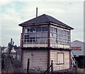
Warmley signal box
Preserved by local enthusiasts, this box was saved from the axe and is open to visitors. The occupants appear to be mannequins.
Image: © Neil Owen
Taken: 26 Sep 2018
0.05 miles
4
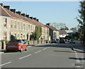
2009 : Tower Road North, Warmley
A pleasant looking terrace built in local stone, a little near the road but double or even triple glazing should help.
Tower Roads North and South pass through Cadbury Heath on their way to meet the A4175 at Oldland Common, by which time they have become West Street.
Image: © Maurice Pullin
Taken: 12 Oct 2009
0.06 miles
6
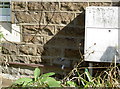
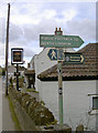
Benchmark by the railway station
This cutmark (listed in the Benchmark Database: https://www.bench-marks.org.uk/bm79381 ) resides on a building near the old Warmley railway station, facing the old London Road. See Image] for a wider view.
Image: © Neil Owen
Taken: 26 Sep 2018
0.06 miles
7
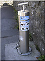
Better by bike
Even better with some air in the tyres! Warmley railway station now serves cyclists instead.
Image: © Neil Owen
Taken: 26 Sep 2018
0.07 miles
8
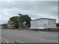
Former signal box and modern commercial building, Warmley
Image: © David Smith
Taken: 10 Jun 2017
0.07 miles
9
Dramway path
The old colliery area to the north and east of early Bristol produced many tons of coal. Transporting the goods to a more connected site nearer the River Avon necessitated the creation of a small gauge railway - the Dramway. Originally powered by horse and later by engines, it has now become a popular footpath. North Common is a mile or so to the south.
Image: © Neil Owen
Taken: 21 Mar 2017
0.07 miles
10
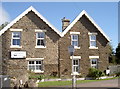
Right by the station
These two buildings are right beside the old Warmley railway station, although now in private hands. A benchmark can be seen on the right-hand house by the electricity meter box - see Image
Image: © Neil Owen
Taken: 26 Sep 2018
0.07 miles