IMAGES TAKEN NEAR TO
Chiltern Close, BRISTOL, BS30 8UJ
Introduction
This page details the photographs taken nearby to Chiltern Close, BS30 8UJ by members of the Geograph project.
The Geograph project started in 2005 with the aim of publishing, organising and preserving representative images for every square kilometre of Great Britain, Ireland and the Isle of Man.

There are currently over 7.5m images from over14,400 individuals and you can help contribute to the project by visiting https://www.geograph.org.uk
Image Map (Loading...)


Getting Data...Please wait
Leaflet Map data © OpenStreetMap
Images are licensed for reuse under creativecommons.org/licenses/by-sa/2.0
Notes
- Clicking on the map will re-center to the selected point.
- The higher the marker number, the further away the image location is from the centre of the postcode.
Image Listing (19 Images Found)
Images are licensed for reuse under creativecommons.org/licenses/by-sa/2.0
Image
Details
Distance
2
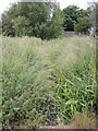
The Batch. Stream in North Common
The stream, bordered by trees viewed from the top of the grass slope in winter 2012/13.
Image: © Vickie
Taken: 18 Jan 2013
0.11 miles
3
The wall's a goal
A brick wall is just the place for a goal and to have a bit of footy. Behind are some garages.
Image: © Neil Owen
Taken: 19 Jun 2021
0.12 miles
4
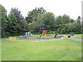
Chiltern Close Play Area
A small set of things for the little ones, fenced off from the Siston Brook just beyond it.
Image: © Neil Owen
Taken: 19 Jun 2021
0.13 miles
5
A small addition to the Siston Brook
A small tributary to the brook runs across Cowhorn Hill. Set in the grasslands around the houses, it has been rather smothered by the undergrowth.
Image: © Neil Owen
Taken: 19 Jun 2021
0.14 miles
6
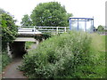
Over and under in The Batch
Mill Lane crosses over the pedestrian underpass. Back in the times of the coal mines it was known as Hole Lane.
Image: © Neil Owen
Taken: 19 Jun 2021
0.14 miles
7
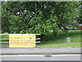
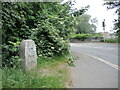
Do the Right Thing
A banner on a section of railings on Mill Lane extoll the virtues of the Covid protocols. Beside it is a parish boundary stone.
Image: © Neil Owen
Taken: 19 Jun 2021
0.15 miles
8
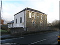
Warmley. South Gloucestershire, Independent Methodist Church
The rock-faced frontage to the mainroad could mean a house but the side windows and the later extension to the rear gives the game away (apart from the signs that is too!)
Image: © ChurchCrawler
Taken: 27 Dec 2005
0.17 miles
9
Bitton Parish stone
A marker at the bottom of Tower Road South, placed in the Millennium.
Image: © Neil Owen
Taken: 19 Jun 2021
0.17 miles
10
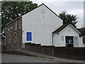
Mill Lane Independent Methodist Church
The Warmley area was once a place of heavy industry, with coal mines, quarrying and the Flock and Shoddy engineering works important employers in the nineteenth century. As is often the case when population numbers rise rapidly, there was a large uptake in church-going, particularly in the Methodist movement. However, the creation of several churches in the area proved to increase contention between various congregations. The Temperance Movement brought matters to a head and there was a split which resulted in this church being founded in 1899.
The building was originally two small houses, and was enlarged after the Independents took over. A new hall was built in 1973 and the church continues its work to this day.
Image: © Neil Owen
Taken: 19 Jun 2021
0.18 miles