IMAGES TAKEN NEAR TO
Tower Road South, BRISTOL, BS30 8BP
Introduction
This page details the photographs taken nearby to Tower Road South, BS30 8BP by members of the Geograph project.
The Geograph project started in 2005 with the aim of publishing, organising and preserving representative images for every square kilometre of Great Britain, Ireland and the Isle of Man.

There are currently over 7.5m images from over14,400 individuals and you can help contribute to the project by visiting https://www.geograph.org.uk
Image Map (Loading...)


Getting Data...Please wait
Leaflet Map data © OpenStreetMap
Images are licensed for reuse under creativecommons.org/licenses/by-sa/2.0
Notes
- Clicking on the map will re-center to the selected point.
- The higher the marker number, the further away the image location is from the centre of the postcode.
Image Listing (26 Images Found)
Images are licensed for reuse under creativecommons.org/licenses/by-sa/2.0
Image
Details
Distance
1
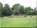
Chiltern Close Play Area
A small set of things for the little ones, fenced off from the Siston Brook just beyond it.
Image: © Neil Owen
Taken: 19 Jun 2021
0.05 miles
2
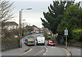
2011 : Tower Road South, Cadbury Heath
Heading south toward Oldland.
This was once a coal mining area but little remains now.
Image: © Maurice Pullin
Taken: 17 Jan 2011
0.08 miles
3
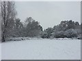
The Batch. Stream in North Common
The stream, bordered by trees viewed from the top of the grass slope in winter 2012/13.
Image: © Vickie
Taken: 18 Jan 2013
0.08 miles
4
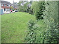
The banks of the Siston Brook
Houses built in the late 1960s have encroached to the top of the steep banks.
Image: © Neil Owen
Taken: 19 Jun 2021
0.10 miles
5
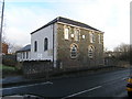
Warmley. South Gloucestershire, Independent Methodist Church
The rock-faced frontage to the mainroad could mean a house but the side windows and the later extension to the rear gives the game away (apart from the signs that is too!)
Image: © ChurchCrawler
Taken: 27 Dec 2005
0.11 miles
6
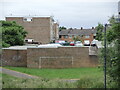
The Batch Youth Centre
As a new, post-war housing estate the area was planned with a large recreation ground for the community to use. The original Cadbury Heath Youth Centre was built a little to the northeast of here and is now new houses. The present building - which started as a pavilion - has been greatly enlarged.
Image: © Neil Owen
Taken: 19 Jun 2021
0.12 miles
7
The wall's a goal
A brick wall is just the place for a goal and to have a bit of footy. Behind are some garages.
Image: © Neil Owen
Taken: 19 Jun 2021
0.13 miles
8
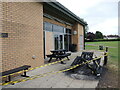
Youth centre and youth activities
The Batch Community and Youth Centre was hit on the evening of 7th June, 2021, by an arson attack. A fire was deliberately started which destroyed a bench and damaged power lines, the alarm system and a window. Police say they have CCTV evidence and have made enquiries. Did the centre not have enough activities for someone?
Image: © Neil Owen
Taken: 19 Jun 2021
0.13 miles
9
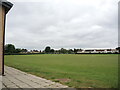
Recreation Ground at The Batches
Once open farmland, part of it has been left as an open space when the modern estate of Cadbury Heath was built in the post-war era.
Image: © Neil Owen
Taken: 19 Jun 2021
0.14 miles
10
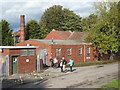
Cowhorn Hill Pumping Station
This is an old colliery site that was redeveloped as a pumping station for the West Gloucester Water Co in 1910. There were two horizontal three cylinder compound pumping engines built in 1910 by Summers & Scott of Gloucester. Steam was superseded in the 1950s when the company was absorbed by the Bristol Waterworks Company. Permission has been granted to demolish these buildings. It is most unusual for the chimney to have survived and it is a shame it is all to be lost.
Image: © Chris Allen
Taken: 19 Oct 2019
0.14 miles