IMAGES TAKEN NEAR TO
Logus Court, BRISTOL, BS30 7EF
Introduction
This page details the photographs taken nearby to Logus Court, BS30 7EF by members of the Geograph project.
The Geograph project started in 2005 with the aim of publishing, organising and preserving representative images for every square kilometre of Great Britain, Ireland and the Isle of Man.

There are currently over 7.5m images from over14,400 individuals and you can help contribute to the project by visiting https://www.geograph.org.uk
Image Map
Images are licensed for reuse under creativecommons.org/licenses/by-sa/2.0
Notes
- Clicking on the map will re-center to the selected point.
- The higher the marker number, the further away the image location is from the centre of the postcode.
Image Listing (12 Images Found)
Images are licensed for reuse under creativecommons.org/licenses/by-sa/2.0
Image
Details
Distance
1
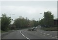
Marsham Way
Marsham Way approaching the junction with Woodward Drive from the north.
Image: © Ruth Riddle
Taken: 4 May 2012
0.12 miles
2
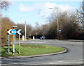
2011 : A4174 Marsham Way, Longwell Green
Roundabout at the end of Marsham Way, leading to the East Bristol bypass.
Image: © Maurice Pullin
Taken: 14 Feb 2011
0.16 miles
3
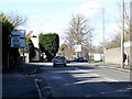
2011 : A431 Bath Road looking north west
The roundabout ahead leads on to Bristol's eastern bypass.
The A431 continues to Hanham, St.George and Bristol Centre.
Image: © Maurice Pullin
Taken: 14 Feb 2011
0.18 miles
4

Sunset over Barrs Court Estate, Bristol
A dramatic late evening picture
Image: © Richard Law
Taken: Unknown
0.19 miles
5
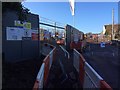
Entrance to footpath PHA 29 and Mount Pleasant farm from A431 road
Temporary closure of footpath with map of alternative route whilst Mount Pleasant farm is developed for housing
Image: © PJK
Taken: 2 Jan 2017
0.22 miles
6
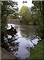
Barr's Court moat
Part of the moat, looking from the large footbridge. See Image] for more views.
Image: © Neil Owen
Taken: 17 Oct 2011
0.22 miles
7
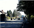
2011 : A431 Bath Road, Longwell Green
Heading toward Willsbridge and Bath.
The No. 45 bus heads for the city centre, and speed sign asks motorists to slow down.
Image: © Maurice Pullin
Taken: 14 Feb 2011
0.22 miles
8

Mi-space, Longwell Green
A new housing development on the site of Mount Pleasant Farm.
Image: © Bill Boaden
Taken: 28 Sep 2017
0.22 miles
9
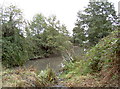
Barr's Court moat
View looking southeast from the small footbridge. See Image] for more views
Image: © Neil Owen
Taken: 17 Oct 2011
0.23 miles
10
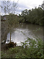
Barr's Court moat
Once a larger feature, part of the eastern side of the moat was filled in during the seventeenth century when a farmhouse was built on the site of the former mansion. See Image] for more views and http://moat1.homestead.com/homepage.html for a comprehensive history.
Image: © Neil Owen
Taken: 17 Oct 2011
0.24 miles