IMAGES TAKEN NEAR TO
Church Road, BRISTOL, BS30 6LJ
Introduction
This page details the photographs taken nearby to Church Road, BS30 6LJ by members of the Geograph project.
The Geograph project started in 2005 with the aim of publishing, organising and preserving representative images for every square kilometre of Great Britain, Ireland and the Isle of Man.

There are currently over 7.5m images from over14,400 individuals and you can help contribute to the project by visiting https://www.geograph.org.uk
Image Map
Images are licensed for reuse under creativecommons.org/licenses/by-sa/2.0
Notes
- Clicking on the map will re-center to the selected point.
- The higher the marker number, the further away the image location is from the centre of the postcode.
Image Listing (55 Images Found)
Images are licensed for reuse under creativecommons.org/licenses/by-sa/2.0
Image
Details
Distance
1
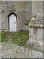
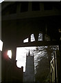
Benchmark on St Mary's, Bitton
A benchmark on the church tower, as listed in the Database: http://www.bench-marks.org.uk/bm39805 . See Image] for a longer view of the tower, once used for canon practice by Cromwell's army.
Image: © Neil Owen
Taken: 17 Oct 2011
0.04 miles
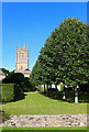
2
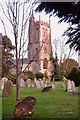
The 12c church of St Mary, Bitton.
It is commonly reported that a 'Grey Lady' (a ghost) is seen occasionally, passing from the vestry southwards and vanishing through the south wall to where there was once a 'Lepers' Window'.
Image: © Paul Wigmore
Taken: Unknown
0.04 miles
3
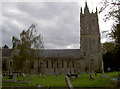
St Mary's, Bitton
This ancient village church can trace its beginnings back to 1086, with the Nave being the only stone structure. The tower was added in Edward III's reign in 1377, and of course there have been many later constructions, particularly by the Victorians. Among the famous who have 'graced' the church was Cromwell's army, who used the tower for canon practice! It remains to this day.
See Image] for a closer view of the tower.
Image: © Neil Owen
Taken: 17 Oct 2011
0.04 miles
4
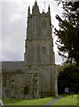
St Mary's church tower, Bitton
First built in 1377, this fine tower has survived Cromwell's army and lightning, which struck in 1680 and destroyed the single spirette. Located at the base is a cut benchmark - see http://www.bench-marks.org.uk/bm39805 for the listing. See also Image] for a wider view of the north side of the church.
Image: © Neil Owen
Taken: 17 Oct 2011
0.04 miles
5
St Mary's Church
Church in the village of Bitton.
Image: © Wayland Smith
Taken: 10 Oct 2021
0.05 miles
6
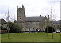
The Grange, Bitton
Before the Reformation, this was the home of
the clergy and was given with much land to the brother of Jane
Seymour, third wife of Henry VIII, by the Abbot of Westminster.
In 1758 the house was let to John Wood the Younger who built
Bath Assembly Rooms, Royal Crescent and Kelston Park.
Image: © Rick Crowley
Taken: 24 Mar 2010
0.05 miles
7
St Mary's through the Lych Gate
Bitton's prominent church and entrance.
Image: © Neil Owen
Taken: 14 Dec 2016
0.05 miles
8
Frere Almshouses
Bitton was blessed by the construction of almshouses in 1859. The five homes were for 'aged married couples or surviving spouses, who shall be members of the Church of England and resident in Bitton for five years.' Above the lintel is the inscription "Frere Ayme Frere" - referring to brotherly love. The front lawns are part allotments.
Image: © Neil Owen
Taken: 14 Dec 2016
0.06 miles
9
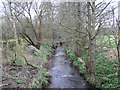
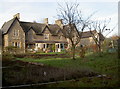
River Boyd
Situated west of Church Road, Bitton.
Image: © Rick Crowley
Taken: 24 Mar 2010
0.09 miles
10
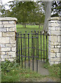
Footpath from St Mary's, Bitton
A 'Kissing' gate allows the supplicants to leave church, cross the cowfield and reach the road beyond.
Image: © Neil Owen
Taken: 17 Oct 2011
0.09 miles