IMAGES TAKEN NEAR TO
Mill Lane, BRISTOL, BS30 6HJ
Introduction
This page details the photographs taken nearby to Mill Lane, BS30 6HJ by members of the Geograph project.
The Geograph project started in 2005 with the aim of publishing, organising and preserving representative images for every square kilometre of Great Britain, Ireland and the Isle of Man.

There are currently over 7.5m images from over14,400 individuals and you can help contribute to the project by visiting https://www.geograph.org.uk
Image Map
Images are licensed for reuse under creativecommons.org/licenses/by-sa/2.0
Notes
- Clicking on the map will re-center to the selected point.
- The higher the marker number, the further away the image location is from the centre of the postcode.
Image Listing (46 Images Found)
Images are licensed for reuse under creativecommons.org/licenses/by-sa/2.0
Image
Details
Distance
1
A really open plan office
The old offices of Bitton's prime employer are a little more expansive now. Given a year or so and it will be a memory.
Image: © Neil Owen
Taken: 14 Dec 2016
0.00 miles
2
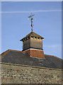
Vane on Golden Valley mill site
A distinctive feature on one of the few old mill and factory buildings still left. See Image] for a wider view.
Image: © Neil Owen
Taken: 14 Dec 2016
0.03 miles
3
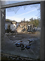
One of a few survivors
The industrial site at Bitton can trace its past quite some time. Originally part of Kingswood Forest and producing coal, the location beside the River Boyd made it prime estate for a mill. William Champion, a leading brass pioneer, set up here in about 1761. The mill produced brass and later paper, but there was a major fire in the nineteenth century that destroyed much of the works.
After a rebuilding, the site returned to paper milling; records of 1895 reveal the firm employed over 400 workers, continuously making envelopes and government stationery. This carried on until 1963, when Canadian owners Intier took over; they specialised in wood fibre parts for the automotive sector. They supplied moulded parts to Ford, Rover, Saab, and Jaguar. However, the business folded in 2006.
Today the site is being cleared for a housing development, with a select group of buildings spared due to their Grade II status. See Image] for a closer view of the vane.
Image: © Neil Owen
Taken: 14 Dec 2016
0.03 miles
4
Mill Lane looks so different now
The old mill and factory site in Bitton has come to an end. Over 250 years of brass and paper production is being razed to the ground; a large housing development is about to rise over it.
Image: © Neil Owen
Taken: 14 Dec 2016
0.04 miles
5
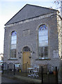
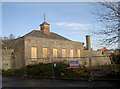
The old Methodist Church
Bitton has had a relatively small population but boasted up to thirteen places of worship. Few remain these days, including this Methodist church. Founded in 1859, it is now in private hands.
Image: © Neil Owen
Taken: 14 Dec 2016
0.04 miles
6
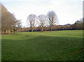
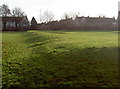
Old bumps or Roman lumps?
The earthworks to the north of the main Bath Road in Bitton were generally thought to be Roman for many years. The Via Julia reaches from Bath and runs close by the village and there are other relevant Roman era points to note. However, excavations in the 1950s returned nothing older than early Mediaeval.
This is the west end of the earthworks.
Image: © Neil Owen
Taken: 14 Dec 2016
0.06 miles
7
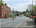
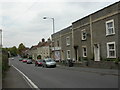
2009 : A431 at Bitton
Looking south east toward Kelston and Bath.
The village is at the half way point between Bristol and Bath, 6 miles each way.
Image: © Maurice Pullin
Taken: 2 May 2009
0.06 miles
8
It looked like a villa
Early Victorian antiquarians presumed this set of earthworks were Roman, possibly a villa or farmstead with a bath-house. However, investigations revealed nothing earlier than about the thirteenth century.
View across the north side, including possible entrances.
Image: © Neil Owen
Taken: 14 Dec 2016
0.07 miles
9
Bitton, convenience stores
On Bath Road; established 1911.
Image: © Mike Faherty
Taken: 8 Oct 2010
0.07 miles
10
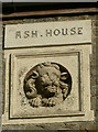
Ash House
The lion looks rather startled and fearful that his house might be due to receive a visit from the bulldozers. See Image] for a wider look at the surviving houses.
Image: © Neil Owen
Taken: 14 Dec 2016
0.07 miles