IMAGES TAKEN NEAR TO
Keynsham Road, BRISTOL, BS30 6EQ
Introduction
This page details the photographs taken nearby to Keynsham Road, BS30 6EQ by members of the Geograph project.
The Geograph project started in 2005 with the aim of publishing, organising and preserving representative images for every square kilometre of Great Britain, Ireland and the Isle of Man.

There are currently over 7.5m images from over14,400 individuals and you can help contribute to the project by visiting https://www.geograph.org.uk
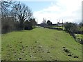
Image Map (Loading...)


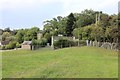
Getting Data...Please wait
Leaflet Map data © OpenStreetMap
Images are licensed for reuse under creativecommons.org/licenses/by-sa/2.0
Notes
- Clicking on the map will re-center to the selected point.
- The higher the marker number, the further away the image location is from the centre of the postcode.
Image Listing (123 Images Found)
Images are licensed for reuse under creativecommons.org/licenses/by-sa/2.0
Image
Details
Distance
1
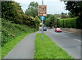
Symbols to follow ahead, Willsbridge
A brown sign alongside the A4175 tells you to follow a badger's head symbol for Willsbridge Mill
or a child's toy locomotive symbol for Avon Valley Railway.
Image: © Jaggery
Taken: 3 Sep 2011
0.02 miles
2
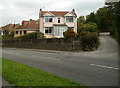
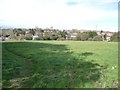
Keynsham Road houses, Willsbridge
The houses are in the south of the village, about 250 metres south of the A431 Bath Road junction.
Image: © Jaggery
Taken: 3 Sep 2011
0.03 miles
3
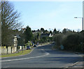
2010 : A4175 Keynsham Road
Taken from the roundabout on the A431 at Willsbridge. Heading across the Avon Valley to Keynsham.
Image: © Maurice Pullin
Taken: 15 Mar 2010
0.04 miles
4
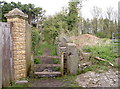
Path to Bitton
A wooden stile to negotiate as the path runs past the back of a number of private properties.
Image: © Neil Owen
Taken: 28 Mar 2017
0.05 miles
5
Tramroad Junction, near Clack Mill - looking north
Looking north along the course of the tramroad from the entrance to the tunnel under the Keynsham Road (now the A4175). See Image In the immediate foreground the widening of the low embankment marks the point at which the branch to Londonderry Wharf split off, see: Image The nearby buildings are those of Clack Mill Farm Stables.
Image: © Martin Tester
Taken: 27 Sep 2019
0.05 miles
6
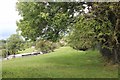
Farmland between the Bath and Keynsham Roads
On the southern edge of Willsbridge.
Image: © Christine Johnstone
Taken: 27 Mar 2016
0.05 miles
7
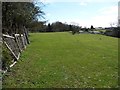
The Dramway, heading south from the Bath Road
Opened in 1832 as a horse-drawn waggonway, taking coal down to a wharf on the River Avon.
Image: © Christine Johnstone
Taken: 27 Mar 2016
0.06 miles
8
Tramroad Junction, near Clack Mill - looking south
Looking south along the course of the tramroad towards the entrance to the tunnel under the Keynsham Road which can just be seen under the trees. See Image The branch to Londonderry Wharf splits off to the right just before it, see: Image
Image: © Martin Tester
Taken: 27 Sep 2019
0.07 miles
9
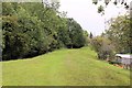
Junction on the Dramway, near Clack Mill
The original route of the horse-drawn waggonway went through the bridge under the trees, south to a wharf on the River Avon. A later route veered right [south-west] to Londonderry Wharf on the River Avon Image Image, thus shortening the river route to Bristol by about a mile and one lock.
Image: © Christine Johnstone
Taken: 27 Mar 2016
0.08 miles
10
The tramroad at Willsbridge Land Wharf
Access to this section of the Dramway path is made from the Keynsham Road (the A4175) through the metal gate on the right. The tramroad has come down from Willsbridge Tunnel, across the A431, & past Brock House in the background (see: Image). From about 1881 to the tramroad's closure in 1904 there was a land-wharf here, comprising loop & siding, to allow coal from California Colliery to be sold locally. In recent years the site has been built upon; the stone-built pumping station with aerials belongs to the local Water Company.
Image: © Martin Tester
Taken: 27 Sep 2019
0.08 miles