IMAGES TAKEN NEAR TO
Kites Farm Lane, BRISTOL, BS30 6AH
Introduction
This page details the photographs taken nearby to Kites Farm Lane, BS30 6AH by members of the Geograph project.
The Geograph project started in 2005 with the aim of publishing, organising and preserving representative images for every square kilometre of Great Britain, Ireland and the Isle of Man.

There are currently over 7.5m images from over14,400 individuals and you can help contribute to the project by visiting https://www.geograph.org.uk
Image Map
Images are licensed for reuse under creativecommons.org/licenses/by-sa/2.0
Notes
- Clicking on the map will re-center to the selected point.
- The higher the marker number, the further away the image location is from the centre of the postcode.
Image Listing (48 Images Found)
Images are licensed for reuse under creativecommons.org/licenses/by-sa/2.0
Image
Details
Distance
1
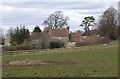
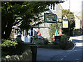
Cottages at Upton Cheyney
These early C18 cottages http://www.imagesofengland.org.uk/Details/Default.aspx?id=28621&mode=adv next to Holister's Farm are seen from the Monarch's Way as it climbs into the village from Bitton.
Image: © Derek Harper
Taken: 9 Mar 2010
0.01 miles
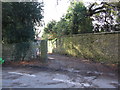
2
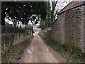
Monarch's Way in Upton Cheyney
The Way leaves the village down this walled track, following footpath PBN 33.
Image: © Derek Harper
Taken: 9 Mar 2010
0.06 miles
3
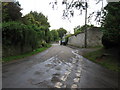
Looking south from the top of Mill Lane
Image: © William Avery
Taken: 30 Sep 2006
0.07 miles
4
Upton Cheyney, street furniture
Noticeboard, postbox and phonebox on Brewery Hill.
Image: © Mike Faherty
Taken: 8 Oct 2010
0.07 miles
5
2010 : The Upton Inn, Upton Cheyney
On Brewery Hill, suggests they brewed their own beer at one time.
It has its own website at: http://www.uptoninn.com/ unfortunately appears to have no history which I find difficult to believe.
Apologies to the Upton Inn, found the following in: http://www.uptoninn.co.uk/id15.html
"The Upton Inn was built around 1710 incorporating an earlier structure and has been recently extended. The road is named after Springfield Brewery, (which is now the site of Brewery Cottages) the brewery used hops from the adjoining fields."
Image: © Maurice Pullin
Taken: 15 Mar 2010
0.08 miles
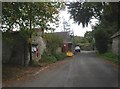
6
Footpath off Brewery Hill
A viewlooking to the west from Brewery Hill to the start of the public footpath to Bitton. Presumably the step-through is a holdover from a time when the track would have been gated.
Image: © Phil Williams
Taken: 7 Mar 2007
0.08 miles
7
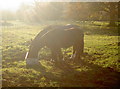
A quiet drink for two
This friendly pair of horses came over to greet the unexpected Geographer at the gate, liberally dampening his coat. All very nice.
Image: © Neil Owen
Taken: 25 Nov 2016
0.09 miles
8
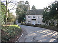
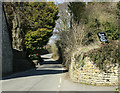
Brewery Hill
A viewlooking to the southwest down Brewery Hill towards the Upton Inn.
Image: © Phil Williams
Taken: 7 Mar 2007
0.09 miles
10
2010 : Brewery Hill, Upton Cheyney
Not far to the farm shop.
"It is thought that the name Upton Cheyney is derived simply from the words 'upper farmhouse'. Archaeological records indicate the site of a Roman settlement to the south-east of the village and at nearby Pipley Bottom the stepped terraces, cut by Romano-Britons for vine cultivation can still be seen. It is likely that the present settlement grew up around springs and above the marshy river valleys. Manor Farm at the junction of Wick Lane was mentioned in the Domesday Book and most of the buildings in the village were constructed between 1690 and 1830."
The above was copied from: http://www.southglos.gov.uk/NR/exeres/190e4f17-e4da-4292-9081-f3ba74166e54 where there is more.
Image: © Maurice Pullin
Taken: 15 Mar 2010
0.10 miles