IMAGES TAKEN NEAR TO
Summers Drive, BRISTOL, BS30 5SZ
Introduction
This page details the photographs taken nearby to Summers Drive, BS30 5SZ by members of the Geograph project.
The Geograph project started in 2005 with the aim of publishing, organising and preserving representative images for every square kilometre of Great Britain, Ireland and the Isle of Man.

There are currently over 7.5m images from over14,400 individuals and you can help contribute to the project by visiting https://www.geograph.org.uk
Image Map (Loading...)


Getting Data...Please wait
Leaflet Map data © OpenStreetMap
Images are licensed for reuse under creativecommons.org/licenses/by-sa/2.0
Notes
- Clicking on the map will re-center to the selected point.
- The higher the marker number, the further away the image location is from the centre of the postcode.
Image Listing (59 Images Found)
Images are licensed for reuse under creativecommons.org/licenses/by-sa/2.0
Image
Details
Distance
1
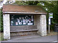
Two uses
The bus shelter and village notice board - all in one.
Image: © Neil Owen
Taken: 20 Oct 2016
0.05 miles
2
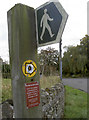
Monarch's Way marker
The long distance path recalls the flight of Charles II and passes through Doynton and the church.
Image: © Neil Owen
Taken: 20 Oct 2016
0.05 miles
3
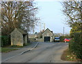
2008 : Doynton, Toghill Lane
At the junction of Toghill Lane and Church Road. The scene gives an idea of the quiet nature of the village.
-----------------------------------
"Doynton's history can be traced back to the Domesday Book (1086) in which the village is mentioned as having two mills. One was probably a corn mill and the other a tucking or fulling mill connected with the Cotswold woollen cloth industry. Both these mills were important to the survival of the village and were referred to again in historical records 500 years later. The tuck mill, however, is not mentioned after the middle of the 17th century. The corn mill continued in use until the 1950s marking nine centuries of service to the village. The mill wheel and old machinery were then broken up and electrically-powered equipment installed. More recently a light engineering firm has taken over the site."
The above was copied from: http://en.wikipedia.org/wiki/Doynton
Image: © Maurice Pullin
Taken: 29 Dec 2008
0.05 miles
4
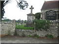
Doynton: The War Memorial
Doynton's War Memorial is in the churchyard of Image A segment of the original churchyard boundary wall has been cut out and replaced by railings to allow people to see the memorial without entering the churchyard.
Image: © Nigel Cox
Taken: 25 Jun 2011
0.05 miles
5
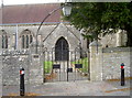
Gates to Holy Trinity
These gates to the church have the initials 'E C'. They remember Elizabeth Canby, who died on 20th April, 1947 aged only 17. A plaque also reads 'The Lord shall preserve thy going out and thy coming in.'
The arch over the gates is a structure created for the Queen's Silver jubilee and includes a welcoming light.
Image: © Neil Owen
Taken: 20 Oct 2016
0.05 miles
6
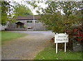
Doynton village hall
Doynton Village Hall was given to the residents of the Parish of Doynton by Charles Samuel Clarke in 1937, for the purpose of “physical and mental recreation and social, moral and intellectual development”.
Image: © Neil Owen
Taken: 20 Oct 2016
0.05 miles
7
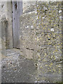
Holy Trinity benchmark
A cutmark, dating from the nineteenth century, on Holy Trinity church. See http://www.bench-marks.org.uk/bm79378 for the entry in the Benchmark Database.
Image: © Neil Owen
Taken: 20 Oct 2016
0.06 miles
8
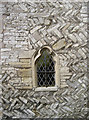
Herringbone church wall
Parts of Holy Trinity dates from the twelfth century and this 'herringbone' style of masonry is very unusual for this part of the country.
Image: © Neil Owen
Taken: 20 Oct 2016
0.06 miles
9
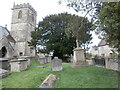
Graveyard of Holy Trinity Church, Doynton
The graveyard contains the village war memorial. This is the site of two Commonwealth War Graves, one from each of the two world wars. Further details at https://www.cwgc.org/visit-us/find-cemeteries-memorials/cemetery-details/2046868/doynton-holy-trinity-churchyard/ and https://sites.southglos.gov.uk/war-memorials/war-memorials/doynton/ . Beyond the graveyard runs Church Road.
Image: © HelenK
Taken: 12 Feb 2022
0.06 miles
10
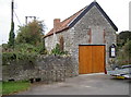
Six ton limit
A small barn near the church has a Women's Institute notice board for good measure. The road here drops slightly and allows rainwater to drop into a small ditch below via drains. Looking closer at the cast iron plate in the wall (see Image]) it reveals the fact that this bit of tarmac is actually a bridge.
Image: © Neil Owen
Taken: 20 Oct 2016
0.06 miles