IMAGES TAKEN NEAR TO
Freezinghill Lane, BRISTOL, BS30 5RT
Introduction
This page details the photographs taken nearby to Freezinghill Lane, BS30 5RT by members of the Geograph project.
The Geograph project started in 2005 with the aim of publishing, organising and preserving representative images for every square kilometre of Great Britain, Ireland and the Isle of Man.

There are currently over 7.5m images from over14,400 individuals and you can help contribute to the project by visiting https://www.geograph.org.uk
Image Map (Loading...)


Getting Data...Please wait
Leaflet Map data © OpenStreetMap
Images are licensed for reuse under creativecommons.org/licenses/by-sa/2.0
Notes
- Clicking on the map will re-center to the selected point.
- The higher the marker number, the further away the image location is from the centre of the postcode.
Image Listing (20 Images Found)
Images are licensed for reuse under creativecommons.org/licenses/by-sa/2.0
Image
Details
Distance
1
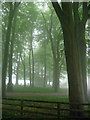
Beeches near Wick
Ghostly in early morning mist. Sun and blue skies prevailed by early afternoon.
Image: © Stephen Richards
Taken: 24 May 2012
0.05 miles
2
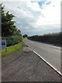
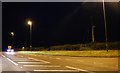
Freezinghill Lane near the junction with the A420
Anyone who regularly drives over Lansdown Hill to get to the M4 is likely to have spent time queueing on this stretch of road. The name is apt as this area is noticeably colder than central Bath or the other side of the A420. The sign advertises a pottery studio nearby, Blue Leaf Ceramics https://blueleafceramics.co.uk/ .
Image: © HelenK
Taken: 18 Jun 2016
0.09 miles
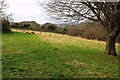
4
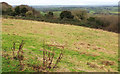
Grassland on Tog Hill
The southwestern corner of the field seen in Image], with a good view - well, in better weather than this - towards Keynsham.
Image: © Derek Harper
Taken: 7 Dec 2019
0.14 miles
5
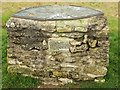
Toposcope, Tog Hill
Image: © Derek Harper
Taken: 7 Dec 2019
0.16 miles
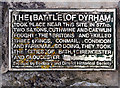
6
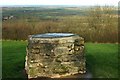
2007 : In the Tog Hill picnic site
The plaque on the side of this toposcope is inscribed
THE BATTLE OF DYRHAM TOOK PLACE NEAR THIS SITE IN 577 AD. TWO SAXONS, CUTHWINE AND CAEWLIN FOUGHT THE BRITONS AND KILLED THREE KINGS, CONMAIL, CONDIDON AND FARINMAIL. SO DOING, THEY TOOK THE CITIES OF BATH, CIRENCESTER AND GLOUCESTER.
Erected by Sodbury and District Historical Society
http://www.chippingsodbury.org/index.htm
The Britons were eventually driven out by the Saxons and took refuge in Wales. They have been there ever since. According to the Saxons they were a quarrelsome lot, always fighting, and deserved what they got. But remember, it is the victors who write the historical records.
Image: © Maurice Pullin
Taken: 10 Dec 2007
0.17 miles
7
Information plaque, Picnic Area, Gorse Lane, Tog Hill, Wick
Image: © Jo and Steve Turner
Taken: 18 Oct 2010
0.17 miles
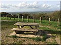
10
By Toghill Picnic Area
Not much of a picnic area, you may be thinking, looking at the vestiges of a picnic table, but then I discovered some more complete tables around to the left. The wood on the right is Toghill Grove.
Image: © Derek Harper
Taken: 7 Dec 2019
0.18 miles