IMAGES TAKEN NEAR TO
Church Avenue, BRISTOL, BS30 5JJ
Introduction
This page details the photographs taken nearby to Church Avenue, BS30 5JJ by members of the Geograph project.
The Geograph project started in 2005 with the aim of publishing, organising and preserving representative images for every square kilometre of Great Britain, Ireland and the Isle of Man.

There are currently over 7.5m images from over14,400 individuals and you can help contribute to the project by visiting https://www.geograph.org.uk
Image Map (Loading...)


Getting Data...Please wait
Leaflet Map data © OpenStreetMap
Images are licensed for reuse under creativecommons.org/licenses/by-sa/2.0
Notes
- Clicking on the map will re-center to the selected point.
- The higher the marker number, the further away the image location is from the centre of the postcode.
Image Listing (28 Images Found)
Images are licensed for reuse under creativecommons.org/licenses/by-sa/2.0
Image
Details
Distance
2
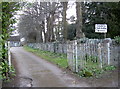
Church gates and no kissing!
This route to the hall runs alongside St Barnabas - with an old kissing gate.
Image: © Neil Owen
Taken: 21 Mar 2017
0.06 miles
3
Five miles to Bristol
An old style of 'S' on this milestone on the A420 in Warmley.
Image: © Neil Owen
Taken: 21 Mar 2017
0.06 miles
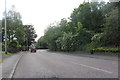
4
2009 : A420 at the top of Warmley Hill
Bridge Yate is about half a mile behind, Warmley and Kingswood ahead then the delights of Bristol.
Image: © Maurice Pullin
Taken: 12 Oct 2009
0.07 miles
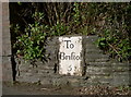
5
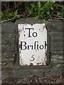
Old Milestone by the A420, London Road, Siston parish
Metal plate attached to wall by the A420, in parish of SISTON (SOUTH GLOUCESTERSHIRE District), London Road, Bridgeyate, opposite junction with Church Avenue, in rubble stone wall, on North side of road. Bristol incised iron plate, erected by the Bristol turnpike trust in the 18th century.
Inscription reads:-
To
Briftol
5
Grade II listed.
List Entry Number: 1231482 https://historicengland.org.uk/listing/the-list/list-entry/1231482
Milestone Society National ID: GL_BRCP05.
Image: © M Faherty
Taken: 7 Apr 2010
0.07 miles
6
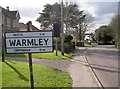
Warmley sign
A friendly and possibly pre-Worboys era sign is followed by a speed monitoring display.
Image: © Neil Owen
Taken: 21 Mar 2017
0.08 miles
7
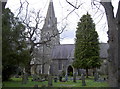
St Barnabas, Warmley
The church has served many of the old railway industry, and coal and ore mining area in the nineteenth century.
Image: © Neil Owen
Taken: 21 Mar 2017
0.09 miles
8
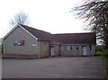
St Barnabas Jubilee Hall
A hall of 1977 vintage. It was built close to some old mineworkings in an area known for them.
Image: © Neil Owen
Taken: 21 Mar 2017
0.09 miles
9
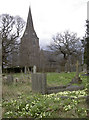
St Barnabas in Spring
The showery weather briefly casts a cloud over the graveyard.
Image: © Neil Owen
Taken: 21 Mar 2017
0.09 miles
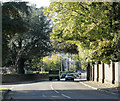
10
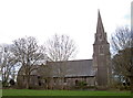
The spire of Warmley
St Barnabas church was founded in 1849 on land once owned by the Tilley family. It opened for worship in 1851 as St Barnabas but was locally called Tilley's church.
Image: © Neil Owen
Taken: 21 Mar 2017
0.09 miles