IMAGES TAKEN NEAR TO
Faye Close, BS30 5AE
Introduction
This page details the photographs taken nearby to Faye Close, BS30 5AE by members of the Geograph project.
The Geograph project started in 2005 with the aim of publishing, organising and preserving representative images for every square kilometre of Great Britain, Ireland and the Isle of Man.

There are currently over 7.5m images from over14,400 individuals and you can help contribute to the project by visiting https://www.geograph.org.uk
Image Map (Loading...)


Getting Data...Please wait
Leaflet Map data © OpenStreetMap
Images are licensed for reuse under creativecommons.org/licenses/by-sa/2.0
Notes
- Clicking on the map will re-center to the selected point.
- The higher the marker number, the further away the image location is from the centre of the postcode.
Image Listing (50 Images Found)
Images are licensed for reuse under creativecommons.org/licenses/by-sa/2.0
Image
Details
Distance
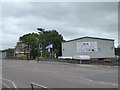
1

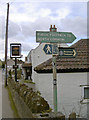
London Road, Warmley
Looking towards Metric Windows
Image: © David Howard
Taken: 1 Jun 2019
0.05 miles
2
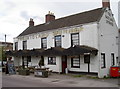
The Midland Spinner
This old hotel is one of many that appeared to cater for the growing railway network of the nineteenth century. It was formerly known as the Midland Railway Hotel (and the pub was the Crown, after the Crown Colliery nearby); however, in 1972 it was ordered under the Trades Description Act to change its name. The new name of Midland Spinner was chosen and recalls an old type of steam locomotive.
Image: © Neil Owen
Taken: 21 Mar 2017
0.07 miles
3
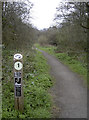
Venture out after dark!
The paths through Warmley Forest Park are a fairly recent creation as this was a former clayworks and then landfill site. Nevertheless, the wildlife has taken to it with enthusiasm and it is now home to bats. This path marker actually glows in the dark and provides a means for people to go out in search of the nocturnal mammals. Indeed, the local library can supply information to use on the walks as well as a bat detector!
Image: © Neil Owen
Taken: 21 Mar 2017
0.09 miles
4
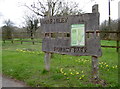
Warmley Forest Park
Entrance to the park, offering lots of fresh air, wildlife and long walks. It is also host to a number of more energetic runs.
Image: © Neil Owen
Taken: 21 Mar 2017
0.10 miles
5
Warmley Forest Park
The area around the village was once awash with coal and ore mining, clay extraction, pipe works and the railways. The heavy industry declined in the twentieth century and was closed by the 1960s. The empty pits and pans were used for landfill, which also ended and the land capped over. New trees were introduced to provide a natural place for relaxation. The forest park offers many varied walks or orienteering runs.
Image: © Neil Owen
Taken: 21 Mar 2017
0.10 miles
6
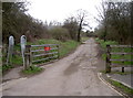
Dramway path
The old colliery area to the north and east of early Bristol produced many tons of coal. Transporting the goods to a more connected site nearer the River Avon necessitated the creation of a small gauge railway - the Dramway. Originally powered by horse and later by engines, it has now become a popular footpath. North Common is a mile or so to the south.
Image: © Neil Owen
Taken: 21 Mar 2017
0.11 miles
8
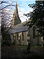
Warmley, South Gloucestershire, St Barnabas Parish Church
Built 1849-50, this church is really only photogenic in the winter as the large number of mature trees in the churchyard hide much of it from view when in leaf!
Image: © ChurchCrawler
Taken: 27 Dec 2005
0.12 miles
9
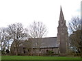
The spire of Warmley
St Barnabas church was founded in 1849 on land once owned by the Tilley family. It opened for worship in 1851 as St Barnabas but was locally called Tilley's church.
Image: © Neil Owen
Taken: 21 Mar 2017
0.12 miles
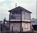
10
Former signal box and modern commercial building, Warmley
Image: © David Smith
Taken: 10 Jun 2017
0.12 miles