IMAGES TAKEN NEAR TO
St. Matthias Park, BRISTOL, BS2 9DP
Introduction
This page details the photographs taken nearby to St. Matthias Park, BS2 9DP by members of the Geograph project.
The Geograph project started in 2005 with the aim of publishing, organising and preserving representative images for every square kilometre of Great Britain, Ireland and the Isle of Man.

There are currently over 7.5m images from over14,400 individuals and you can help contribute to the project by visiting https://www.geograph.org.uk
Image Map
Images are licensed for reuse under creativecommons.org/licenses/by-sa/2.0
Notes
- Clicking on the map will re-center to the selected point.
- The higher the marker number, the further away the image location is from the centre of the postcode.
Image Listing (364 Images Found)
Images are licensed for reuse under creativecommons.org/licenses/by-sa/2.0
Image
Details
Distance
1
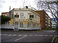
The only way is down
The Seven Ways public house, now closed having seen better days.
Image: © Anthony Vosper
Taken: 17 Mar 2012
0.01 miles
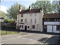
2
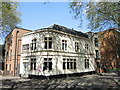
Parting of the Seven Ways
The name Seven Ways is thought to originate from the convergence of seven ancient routes that once went on to Bristol, Gloucester and London. However, the pub was failing to stay afloat and became a community asset in recent years. Sadly, that too did not survive and the site was sold off in 2012 to be converted into flats. It was pretty much gutted and rebuilt from a shell.
In the beginning it was a pub called the Swan, being built as the area was being developed in the nineteenth century.
Image: © Neil Owen
Taken: 26 Apr 2022
0.01 miles
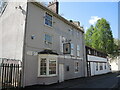
3
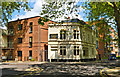
The Seven Ways
A former pub, now converted to housing. Looking better for it, too.
Image: © Philip Pankhurst
Taken: 26 May 2016
0.01 miles
4
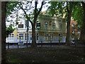
The Seven Ways
Disused pub in a shady spot on Redcross Street.
Image: © Thomas Nugent
Taken: 7 Sep 2010
0.02 miles
5
The Volunteer Tavern, New Street
In the past Pubs called The Volunteer would be the mustering points for a call to arms. The sign to this particular pub is just plain, but in the past could have displayed the uniform to the local regiment of which the gathered troops would serve.
There are a large number of pubs in this square.
Image: © Anthony Vosper
Taken: 28 May 2012
0.02 miles
6
The Volunteer Tavern, New Street
The pub has survived the many changes in the street. Originally there was a long terrace here, of which few other remain. It proudly claims to be the first pub in Bristol to become a Living Wage employer.
Image: © Neil Owen
Taken: 26 Apr 2022
0.03 miles
7
Bristol City Mission, Great George Street
It looks like this building is now used as a hostel rather than a mission church.
Image: © Anthony Vosper
Taken: 28 May 2012
0.04 miles
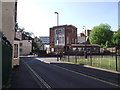
8
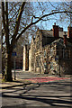
St Matthias Park, Bristol
Another view of the tree-lined road shown in Image], with an entrance to the park with the same name as the street. Beyond are three levels of buildings: St Matthias House (flats), Phoenix Court (student accommodation), and then Castlemead, Bristol's tallest building.
Image: © Derek Harper
Taken: 5 Apr 2018
0.04 miles
9
7 Redcross Street
A fine Early Georgian house (the birthplace of painter Thomas Lawrence in 1769) is incongruously sandwiched between 2 chunks of Lego-Brutalism, a bizarre sight in a part of Bristol very short of fine architecture. The architects in 1974 were Elsom, Pack and Roberts. To think that it took 3 people to come up with this.
Image: © Philip Pankhurst
Taken: 26 May 2016
0.04 miles
10
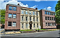
Andalusia Academy, St Philips, Bristol
The school occupies the Old School Building between St Matthias Park and Redcross Street.
Image: © Derek Harper
Taken: 5 Apr 2018
0.05 miles