IMAGES TAKEN NEAR TO
Hillmer Rise, BANWELL, BS29 6HX
Introduction
This page details the photographs taken nearby to Hillmer Rise, BS29 6HX by members of the Geograph project.
The Geograph project started in 2005 with the aim of publishing, organising and preserving representative images for every square kilometre of Great Britain, Ireland and the Isle of Man.

There are currently over 7.5m images from over14,400 individuals and you can help contribute to the project by visiting https://www.geograph.org.uk
Image Map (Loading...)


Getting Data...Please wait
Leaflet Map data © OpenStreetMap
Images are licensed for reuse under creativecommons.org/licenses/by-sa/2.0
Notes
- Clicking on the map will re-center to the selected point.
- The higher the marker number, the further away the image location is from the centre of the postcode.
Image Listing (4 Images Found)
Images are licensed for reuse under creativecommons.org/licenses/by-sa/2.0
Image
Details
Distance
2
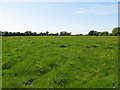
A fertile meadow adjacent to Wolvers Hill Road in Banwell
Image: © Dr Duncan Pepper
Taken: 20 May 2011
0.18 miles
3
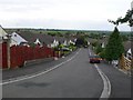
Greenfield Avenue, Banwell
This road runs north off High St down the steep hillside on which the village is built.It is on the very eastern edge of the grid square.
Image: © Nigel Mykura
Taken: 18 Jun 2009
0.18 miles