IMAGES TAKEN NEAR TO
Springfield Gardens, BANWELL, BS29 6HN
Introduction
This page details the photographs taken nearby to Springfield Gardens, BS29 6HN by members of the Geograph project.
The Geograph project started in 2005 with the aim of publishing, organising and preserving representative images for every square kilometre of Great Britain, Ireland and the Isle of Man.

There are currently over 7.5m images from over14,400 individuals and you can help contribute to the project by visiting https://www.geograph.org.uk
Image Map (Loading...)


Getting Data...Please wait
Leaflet Map data © OpenStreetMap
Images are licensed for reuse under creativecommons.org/licenses/by-sa/2.0
Notes
- Clicking on the map will re-center to the selected point.
- The higher the marker number, the further away the image location is from the centre of the postcode.
Image Listing (15 Images Found)
Images are licensed for reuse under creativecommons.org/licenses/by-sa/2.0
Image
Details
Distance
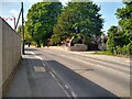
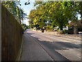
2
Greenfield Avenue, Banwell
This road runs north off High St down the steep hillside on which the village is built.It is on the very eastern edge of the grid square.
Image: © Nigel Mykura
Taken: 18 Jun 2009
0.10 miles
3
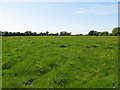
A fertile meadow adjacent to Wolvers Hill Road in Banwell
Image: © Dr Duncan Pepper
Taken: 20 May 2011
0.15 miles
4
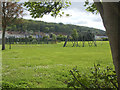
Banwell Recreation Ground
Banwell has expanded westwards from the old square where its historical heart lies. In 1902 local man Robert Day left the field to the village for recreational purposes. The field hosts the village fair every July and previously held occasional harvest festivals.
Image: © Neil Owen
Taken: 10 May 2019
0.17 miles
5
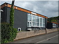
Banwell Village Hall
The recreation ground has been the village's open space for over a century, yet it took about another sixty years for a proper hall to be secured.
Image: © Neil Owen
Taken: 10 May 2019
0.18 miles
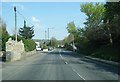
6
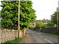
Wolvershill Road
Looking towards the centre of Banwell.
Image: © Richard Webb
Taken: 18 Apr 2011
0.21 miles
7
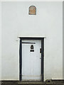
An ancient door
Some historic housing along West Street in Banwell.
Image: © Neil Owen
Taken: 10 May 2019
0.22 miles
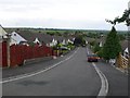
9
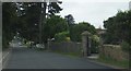
Wolvershill Road
On the northern outskirts of Banwell.
Image: © Ruth Riddle
Taken: 17 Jul 2012
0.24 miles