IMAGES TAKEN NEAR TO
Marlborough Hill Place, BRISTOL, BS2 8LR
Introduction
This page details the photographs taken nearby to Marlborough Hill Place, BS2 8LR by members of the Geograph project.
The Geograph project started in 2005 with the aim of publishing, organising and preserving representative images for every square kilometre of Great Britain, Ireland and the Isle of Man.

There are currently over 7.5m images from over14,400 individuals and you can help contribute to the project by visiting https://www.geograph.org.uk
Image Map
Images are licensed for reuse under creativecommons.org/licenses/by-sa/2.0
Notes
- Clicking on the map will re-center to the selected point.
- The higher the marker number, the further away the image location is from the centre of the postcode.
Image Listing (564 Images Found)
Images are licensed for reuse under creativecommons.org/licenses/by-sa/2.0
Image
Details
Distance
1
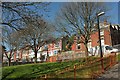
Dove Street, Bristol
Houses at the west end of the street seen from a path through the small park enclosed by a loop of the road. Image] was taken further up the path, looking up the alley on the right.
Image: © Derek Harper
Taken: 20 Apr 2016
0.00 miles
3
Park, Dove Street, Bristol
Looking over the path from which Image was taken, and the park enclosed by the loop of the road.
Image: © Derek Harper
Taken: 20 Apr 2016
0.03 miles
4
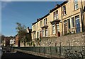
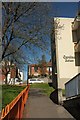
Dove Street, Bristol
Though elevated, the views from this terrace are rather blocked by having Carolina House Image] opposite. Ahead, Dove Street begins to drop and takes a bend through almost 180° around the block of flats and a park.
Image: © Derek Harper
Taken: 20 Apr 2016
0.03 miles
5
Path past Carolina House, Bristol
The path from which Image] was taken, a little higher up. Carolina House, on the right http://www.geograph.org.uk/search.php?i=62642225 is a block of 113 flats. At the top is Dove Street.
Image: © Derek Harper
Taken: 20 Apr 2016
0.03 miles
6
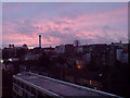
Dusk in Kingsdown
Viewed from top of Carolina House, facing Kingsdown area.
Image: © kandikills
Taken: 7 Jan 2008
0.03 miles
7
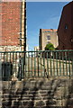
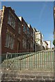
Montague Hill, Bristol
Like Spring Hill Image], an alley with steps at either end preventing vesicles from using it, but less steep. Beyond Somerset Street, both become motorable back lanes.
Image: © Derek Harper
Taken: 20 Apr 2016
0.03 miles
8
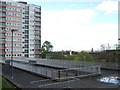
The view from Carolina House
An urban landscape of the post-war variety.
Image: © Neil Owen
Taken: 25 Apr 2019
0.03 miles
9
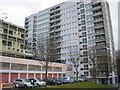
Carolina House flats, Kingsdown, Bristol
This block of flats is situated just to the North of Bristol city centre. It is on a fairly steep hill so the entrance on the North side is halfway up the building!
This block of flats featured prominently in the TV drama series 'Skins' as Maxxie and Sketch both lived here.
Image: © GaryReggae
Taken: 27 Feb 2009
0.04 miles
10
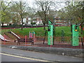
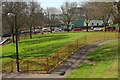
Dove Street South play area
A semicircular patch for the many occupants of the towering blocks of flats to play in.
Image: © Neil Owen
Taken: 25 Apr 2019
0.04 miles