IMAGES TAKEN NEAR TO
St. Michaels Hill, BRISTOL, BS2 8DE
Introduction
This page details the photographs taken nearby to St. Michaels Hill, BS2 8DE by members of the Geograph project.
The Geograph project started in 2005 with the aim of publishing, organising and preserving representative images for every square kilometre of Great Britain, Ireland and the Isle of Man.

There are currently over 7.5m images from over14,400 individuals and you can help contribute to the project by visiting https://www.geograph.org.uk
Image Map (Loading...)


Getting Data...Please wait
Leaflet Map data © OpenStreetMap
Images are licensed for reuse under creativecommons.org/licenses/by-sa/2.0
Notes
- Clicking on the map will re-center to the selected point.
- The higher the marker number, the further away the image location is from the centre of the postcode.
Image Listing (257 Images Found)
Images are licensed for reuse under creativecommons.org/licenses/by-sa/2.0
Image
Details
Distance
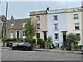
2
St Michael's Hill, Bristol
The pub across the road is the Highbury vaults, A Young's pub dating back to the early 1800s.
Image: © Stephen McKay
Taken: 21 Apr 2018
0.02 miles
3
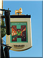
The Highbury Vaults, Bristol
The sign for this pub displays the trademark ram for Young's brewery. Until its closure in 2006, Young's beers were brewed at the Ram Brewery in Wandsworth, London. For the context see: Image
Image: © Stephen McKay
Taken: 21 Apr 2018
0.02 miles
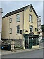
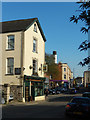
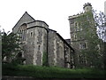
5
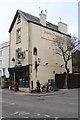
The Highbury Vaults public house
In St Michael's Hill Tyndall's Park.
Image: © Rod Allday
Taken: 11 Mar 2014
0.02 miles
6
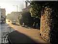
Junction, Cotham
Tyndall's Park Road (right) turns off St Michael's Hill.
Image: © Derek Harper
Taken: 29 Dec 2014
0.02 miles
7
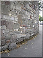
A sinking boundary stone
In common with many such markers in a busy city, this parish boundary stone is slowly disappearing below layer upon layer of tarmac. It lies on the old boundary on St Michael's Hill and has a neighbour - see .
Image: © Neil Owen
Taken: 12 Jul 2017
0.03 miles
8
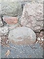
Old Boundary Marker
Parish Boundary Marker against stone wall on the south side of St Michaels Hill, Bristol. It may mark the boundary of St Michael's ward. See also http://www.geograph.org.uk/photo/5462300
Milestone Society National ID: GL_BSSM01pb
Image: © D Dickson
Taken: 5 Jan 2019
0.03 miles
9
Cotham Parish Church
Originally a Congregational Church, it was built in 1842-3 to designs by William Butterfield - an Oxford Movement architect who created these striking Gothic Revival features. This was his first commission, given by local tobacco baron W.D. Wills. From 1975 onwards, it was also known as the Church of St Saviour with St Mary.
Image: © Neil Owen
Taken: 5 Jul 2021
0.03 miles
10
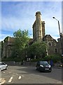
Cotham Parish Church
Cotham Church is a Gothic Revival style church in Cotham, Bristol, England. Since 1975, it has been a Church of England parish church known as the Church of St Saviour with St Mary or simply as Cotham Parish Church.
Cotham Church was originally built in 1842 and completed in 1843 by William Butterfield.
A grade II* listed building.
Image: © Richard Hoare
Taken: 26 Jun 2017
0.03 miles