IMAGES TAKEN NEAR TO
Blakeway, WEDMORE, BS28 4UB
Introduction
This page details the photographs taken nearby to Blakeway, BS28 4UB by members of the Geograph project.
The Geograph project started in 2005 with the aim of publishing, organising and preserving representative images for every square kilometre of Great Britain, Ireland and the Isle of Man.

There are currently over 7.5m images from over14,400 individuals and you can help contribute to the project by visiting https://www.geograph.org.uk
Image Map (Loading...)


Getting Data...Please wait
Leaflet Map data © OpenStreetMap
Images are licensed for reuse under creativecommons.org/licenses/by-sa/2.0
Notes
- Clicking on the map will re-center to the selected point.
- The higher the marker number, the further away the image location is from the centre of the postcode.
Image Listing (10 Images Found)
Images are licensed for reuse under creativecommons.org/licenses/by-sa/2.0
Image
Details
Distance
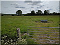
1
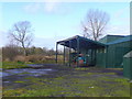
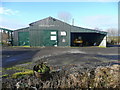
Delfan peat works, Blakeway 2
View to the west of Blakeway.
The machinery seems to be laid up.
Image: © Jonathan Billinger
Taken: 16 Jan 2009
0.03 miles
2
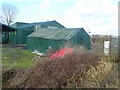
Delfan peat works, Blakeway 3
The buildings are all painted a distinctive shade of green.
Image: © Jonathan Billinger
Taken: 16 Jan 2009
0.05 miles
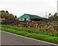
4
Delfan peat works, Blakeway 1
The business is in the centre of the sedge moor of the Somerset Levels.
It looks a bit run down.
Image: © Jonathan Billinger
Taken: 16 Jan 2009
0.05 miles
6
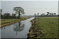
Levels scenery 2
The B3151 crosses this stretch of sedge moor north from Westhay to Mudgley.
Image: © Jonathan Billinger
Taken: 16 Jan 2009
0.13 miles
10
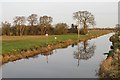
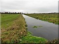
The North Drain on Westhay Moor
The North Drain was dug in c1770 to drain low lying moors to the north of the River Brue.
Image: © Sharon Loxton
Taken: 26 Jan 2008
0.24 miles