IMAGES TAKEN NEAR TO
Mudgley, WEDMORE, BS28 4TY
Introduction
This page details the photographs taken nearby to BS28 4TY by members of the Geograph project.
The Geograph project started in 2005 with the aim of publishing, organising and preserving representative images for every square kilometre of Great Britain, Ireland and the Isle of Man.

There are currently over 7.5m images from over14,400 individuals and you can help contribute to the project by visiting https://www.geograph.org.uk
Image Map (Loading...)


Getting Data...Please wait
Leaflet Map data © OpenStreetMap
Images are licensed for reuse under creativecommons.org/licenses/by-sa/2.0
Notes
- Clicking on the map will re-center to the selected point.
- The higher the marker number, the further away the image location is from the centre of the postcode.
Image Listing (2 Images Found)
Images are licensed for reuse under creativecommons.org/licenses/by-sa/2.0
Image
Details
Distance
1
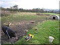
Mudgley Pig
Pig pen on the south facing slope at Mudgley. The view overlooks most of the square. The water in the distance is one of the many lakes formed after excavation of peat.
Image: © Graham Richards
Taken: 27 Dec 2005
0.05 miles
2
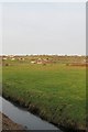
A view towards Mudgley
Taken from Blakeway on Westhay Moor this photograph shows the small settlement of Mudgley on the ridge overlooking the moors - and safe from the perils of flooding.
Image: © Sharon Loxton
Taken: 26 Jan 2008
0.06 miles