IMAGES TAKEN NEAR TO
Bagley, WEDMORE, BS28 4TA
Introduction
This page details the photographs taken nearby to BS28 4TA by members of the Geograph project.
The Geograph project started in 2005 with the aim of publishing, organising and preserving representative images for every square kilometre of Great Britain, Ireland and the Isle of Man.

There are currently over 7.5m images from over14,400 individuals and you can help contribute to the project by visiting https://www.geograph.org.uk
Image Map
Images are licensed for reuse under creativecommons.org/licenses/by-sa/2.0
Notes
- Clicking on the map will re-center to the selected point.
- The higher the marker number, the further away the image location is from the centre of the postcode.
Image Listing (4 Images Found)
Images are licensed for reuse under creativecommons.org/licenses/by-sa/2.0
Image
Details
Distance
2
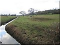
Bagley Cows
Oh dear.... More pictures of cows. I hope no-one starts a picture thread on cows; it could be even longer than one for churches. No it couldn't..... could it?
Image: © Graham Richards
Taken: 27 Dec 2005
0.22 miles
3
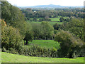
Fields below Mudgley
Glastonbury Tor is just visible on the horizon
Image: © Ken Grainger
Taken: 16 Oct 2011
0.24 miles