IMAGES TAKEN NEAR TO
Lascot Hill, WEDMORE, BS28 4AE
Introduction
This page details the photographs taken nearby to Lascot Hill, BS28 4AE by members of the Geograph project.
The Geograph project started in 2005 with the aim of publishing, organising and preserving representative images for every square kilometre of Great Britain, Ireland and the Isle of Man.

There are currently over 7.5m images from over14,400 individuals and you can help contribute to the project by visiting https://www.geograph.org.uk
Image Map (Loading...)


Getting Data...Please wait
Leaflet Map data © OpenStreetMap
Images are licensed for reuse under creativecommons.org/licenses/by-sa/2.0
Notes
- Clicking on the map will re-center to the selected point.
- The higher the marker number, the further away the image location is from the centre of the postcode.
Image Listing (113 Images Found)
Images are licensed for reuse under creativecommons.org/licenses/by-sa/2.0
Image
Details
Distance
1
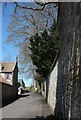
Lascot Hill, Wedmore
This is the road to Lower Weare, leaving Pilcorn Street.
Image: © Derek Harper
Taken: 25 Mar 2016
0.07 miles
2
Approaching the junction with Lascott Hill, Wedmore
Image: © Roger Cornfoot
Taken: 23 Apr 2010
0.07 miles
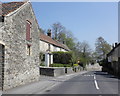
3
Pilcorn Street, Wedmore
In the foreground is the junction with Lascot Hill. The second house along on the right is listed https://www.historicengland.org.uk/listing/the-list/list-entry/1252781 .
Image: © Derek Harper
Taken: 25 Mar 2016
0.08 miles
4
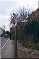
Direction Sign - Signpost on the B3139 in Wedmore
Pyramid finial - 3 arms, 1 missing; Somerset SCC pyramid by the B3139, in parish of Wedmore (Sedgemoor District), on the northwest side of the T junction of the B3139 Pilcorn Street/Church Street and Lascot Hill.
Surveyed
Milestone Society National ID: SO_ST4347B
Image: © J Dowding
Taken: Unknown
0.09 miles
5
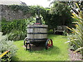
A symbol of rustic relations
An old apple press stands on the corner of Pilcorn Street and St Medard Road. It bears a plaque, marking the village of Wedmore's fruitful twinning with the French village of St Medard-de-Guizieres and its twentieth anniversary.
Image: © Neil Owen
Taken: 27 May 2024
0.10 miles
6

Former manor house, Wedmore
Now divided, the building is early C19 http://webapp1.somerset.gov.uk/her/details.asp?prn=13401 . Seen from close to the western entrance to St Mary's churchyard.
Image: © Derek Harper
Taken: 17 Aug 2011
0.11 miles
7
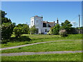
Former Manor House, Wedmore
Now subdivided. Dates from the early nineteenth century https://historicengland.org.uk/listing/the-list/list-entry/1252778?section=official-list-entry
Image: © Jonathan Thacker
Taken: 17 Jun 2024
0.11 miles
8
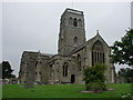
WEDMORE, Somerset
The church of St Mary
Image: © ChurchCrawler
Taken: 20 Jul 2004
0.12 miles
9
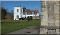
Former manor house, Wedmore
A view of the listed building https://www.historicengland.org.uk/listing/the-list/list-entry/1252778 shown in Image from beside the west end of Image
Image: © Derek Harper
Taken: 25 Mar 2016
0.12 miles
10
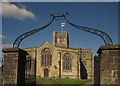
St Mary's Church, Wedmore
The classic view, here framed by the overthrow and gate piers http://list.english-heritage.org.uk/resultsingle.aspx?uid=1252636&searchtype=mapsearch is also shown in Image], Image] and Image The church is described at http://list.english-heritage.org.uk/resultsingle.aspx?uid=1262159&searchtype=mapsearch .
Image: © Derek Harper
Taken: 3 Jun 2013
0.13 miles