IMAGES TAKEN NEAR TO
Comer Road, CHEDDAR, BS27 3AS
Introduction
This page details the photographs taken nearby to Comer Road, BS27 3AS by members of the Geograph project.
The Geograph project started in 2005 with the aim of publishing, organising and preserving representative images for every square kilometre of Great Britain, Ireland and the Isle of Man.

There are currently over 7.5m images from over14,400 individuals and you can help contribute to the project by visiting https://www.geograph.org.uk
Image Map
Images are licensed for reuse under creativecommons.org/licenses/by-sa/2.0
Notes
- Clicking on the map will re-center to the selected point.
- The higher the marker number, the further away the image location is from the centre of the postcode.
Image Listing (52 Images Found)
Images are licensed for reuse under creativecommons.org/licenses/by-sa/2.0
Image
Details
Distance
3
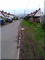
Strawberry Line NCN26 behind Wideatts Road in Cheddar
A view north west along the Strawberry Line path NCN26 as it runs behind houses on Wideatts Road in Cheddar.
The path here has a gravel surface which is loose and uneven in places. The path is narrow all the way along this section between Valley Line Industrial Estate and Lower New Road.
There are problems with accessibility at Valley Line Industrial Estate with a metal barrier and a kerb to negotiate.
Image: © Kevin Pearson
Taken: 17 Sep 2021
0.09 miles
4
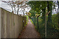
Strawberry Line
Certainly not the best part of the path as it approaches the site of the former Cheddar Station.
Image: © Guy Wareham
Taken: 28 Oct 2016
0.11 miles
6
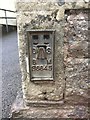
OS Flush Bracket OSBM S6645: Cheddar School
Ordnance Survey - Flush Bracket OSBM S6645: Cheddar School
Image: © thejackrustles
Taken: 2 Apr 2019
0.14 miles
7
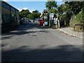
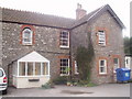
Builders' merchants, Wedmore Road, Cheddar
The Strawberry Line runs to the right of the gate
Image: © David Smith
Taken: 1 Oct 2021
0.14 miles
8
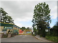
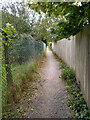
Strawberry Line path, Cheddar
A narrow section of the Strawberry Line path along the side of an industrial site on the site of the former railway station at Cheddar.
Image: © Malc McDonald
Taken: 22 Aug 2020
0.15 miles
9
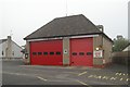
Cheddar fire station
Cheddar fire station, The Hayes, Cheddar, Somerset
Image: © Kevin Hale
Taken: 6 Nov 2006
0.15 miles
10
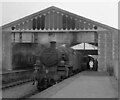
Witham-bound train at Cheddar station
BR Standard 2-6-2T 82037 is at the head of the mid-afternoon train from Yatton (depart 2.45pm) to Witham on the GWR's west of England main line. The leisurely timetable was intended to allow time for the loading & unloading of parcels but it gave the photographer the opportunity to leave the train and record the scene. Withdrawal of the passenger service came 4 months later; the last trains ran on 7th September 1963. Goods traffic from Witham as far as Cheddar lasted for a few more years, ending in April 1969.
Cheddar station was the only one on the line to have an overall roof - a facility denied to that at Wells, surely a more important source of traffic.
Image: © Martin Tester
Taken: 1 May 1963
0.15 miles