IMAGES TAKEN NEAR TO
Stone Allerton, AXBRIDGE, BS26 2NH
Introduction
This page details the photographs taken nearby to BS26 2NH by members of the Geograph project.
The Geograph project started in 2005 with the aim of publishing, organising and preserving representative images for every square kilometre of Great Britain, Ireland and the Isle of Man.

There are currently over 7.5m images from over14,400 individuals and you can help contribute to the project by visiting https://www.geograph.org.uk
Image Map
Images are licensed for reuse under creativecommons.org/licenses/by-sa/2.0
Notes
- Clicking on the map will re-center to the selected point.
- The higher the marker number, the further away the image location is from the centre of the postcode.
Image Listing (3 Images Found)
Images are licensed for reuse under creativecommons.org/licenses/by-sa/2.0
Image
Details
Distance
1
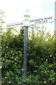
Direction Sign ? Signpost on Rectory Hill, Chapel Allerton parish
Located on the south side of the junction at the north end of Rectory Hill in Chapel Allerton parish. 3 arms, 1 Worboys, and narrow cone on ball finial. Grade II Listed https://historicengland.org.uk/listing/the-list/list-entry/1344914.
Milestone Society National ID: SO_ST4050B
Image: © J Dowding
Taken: Unknown
0.03 miles
2
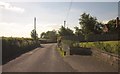
Junction, Allerton
Looking in the other direction from the spot where Image] was taken. The junction is with Rectory Hill, which leads down into Chapel Allerton; straight on is for Stone Allerton. Almost completely hidden behind the tallest tree on the right is the former post office, which closed a few years ago.
Image: © Derek Harper
Taken: 3 Jun 2013
0.03 miles
3
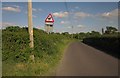
Road at Allerton
The road between Lower Weare and Wedmore passes briefly across the northeast corner of this square, by the time it reaches the second telegraph pole, it is into Image Didn't notice any deer.
Image: © Derek Harper
Taken: 3 Jun 2013
0.06 miles