IMAGES TAKEN NEAR TO
Alston Sutton, Weare, AXBRIDGE, BS26 2LU
Introduction
This page details the photographs taken nearby to BS26 2LU by members of the Geograph project.
The Geograph project started in 2005 with the aim of publishing, organising and preserving representative images for every square kilometre of Great Britain, Ireland and the Isle of Man.

There are currently over 7.5m images from over14,400 individuals and you can help contribute to the project by visiting https://www.geograph.org.uk
Image Map (Loading...)


Getting Data...Please wait
Leaflet Map data © OpenStreetMap
Images are licensed for reuse under creativecommons.org/licenses/by-sa/2.0
Notes
- Clicking on the map will re-center to the selected point.
- The higher the marker number, the further away the image location is from the centre of the postcode.
Image Listing (13 Images Found)
Images are licensed for reuse under creativecommons.org/licenses/by-sa/2.0
Image
Details
Distance
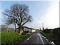
3
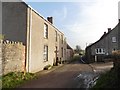
Alston Sutton Road
In the foreground, and again travelling between hedges across the image after rounding the bend seen in Image To the right of the poplars is Alston Sutton Farm.
Image: © Derek Harper
Taken: 4 May 2016
0.09 miles
4
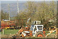
Farmyard machinery graveyard! Alston Sutton
A field full of farming machinery some very rusty.
Image: © Adrian and Janet Quantock
Taken: 28 Jan 2006
0.09 miles
6
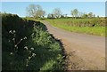
Alston Sutton Road
From the bend seen in Image] and, according to the maps, seen here in between the farming hamlets of Alston Batch (off to the right) and Alston Sutton.
Image: © Derek Harper
Taken: 4 May 2016
0.14 miles
7
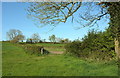
Path reaching Alston Sutton Road
Footpath AX 26/46 meets the lane beyond the gate at a right-angled bend. An ash in bud above the camera.
Image: © Derek Harper
Taken: 4 May 2016
0.19 miles
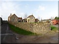
8
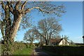
Ashlyn Farm
Alston Sutton Road passes the farm and some ash trees, appropriately.
Image: © Derek Harper
Taken: 4 May 2016
0.20 miles
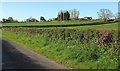
9
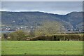
Field with view towards the Mendips
Cheddar Reservoir is visible on the left, with Cheddar Gorge cut into the hills on the right.
Image: © David Martin
Taken: 18 Feb 2023
0.20 miles
10
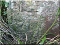
Benchmark on a gatepost on Alston Sutton Road
Right in the middle of the countryside is a stone post with a benchmark on it. See Image] for a look around and https://www.bench-marks.org.uk/bm135428 for the entry in the Benchmark Database.
Image: © Neil Owen
Taken: 11 Oct 2020
0.22 miles