IMAGES TAKEN NEAR TO
Weare, AXBRIDGE, BS26 2JS
Introduction
This page details the photographs taken nearby to BS26 2JS by members of the Geograph project.
The Geograph project started in 2005 with the aim of publishing, organising and preserving representative images for every square kilometre of Great Britain, Ireland and the Isle of Man.

There are currently over 7.5m images from over14,400 individuals and you can help contribute to the project by visiting https://www.geograph.org.uk
Image Map (Loading...)


Getting Data...Please wait
Leaflet Map data © OpenStreetMap
Images are licensed for reuse under creativecommons.org/licenses/by-sa/2.0
Notes
- Clicking on the map will re-center to the selected point.
- The higher the marker number, the further away the image location is from the centre of the postcode.
Image Listing (14 Images Found)
Images are licensed for reuse under creativecommons.org/licenses/by-sa/2.0
Image
Details
Distance
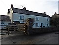
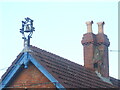
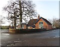
1
Weare Academy First School
One of the school buildings in Weare. See Image] for a special weathervane on the roof.
Image: © Neil Owen
Taken: 11 Oct 2020
0.01 miles
2
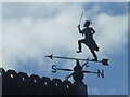
A master stroke of a weathervane
The roof of Weare Academy First School is topped off with a superb piece of metalwork. See Image] for a wider view.
Image: © Neil Owen
Taken: 11 Oct 2020
0.01 miles
3
An ornate school bell
Weare School is over a hundred years old, with what might well be a bell of similar age.
Image: © Neil Owen
Taken: 11 Oct 2020
0.03 miles
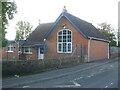
5

Weare Academy First School and Rainbow Woods Pre-School
A small and rather isolated school between Weare and Lower Weare, the playground features some extra large 'pencils'. Quite what the modern generations makes of non-touch screen devices is not clear.
Image: © Neil Owen
Taken: 11 Oct 2020
0.03 miles
6
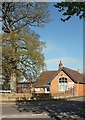
Weare Academy First School
Taken from the same spot as Image], looking across Notting Hill Way. The school dates from 1895.
Image: © Derek Harper
Taken: 4 May 2016
0.03 miles
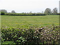
7

Field, Weare
From the junction of Notting Hill Way and Sparrow Hill Way, looking across the levels to the Mendips.
Image: © Derek Harper
Taken: 4 May 2016
0.04 miles
9
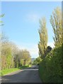
Notting Hill Way
The road has reached the levels after the descent shown in Image At the bend ahead is a right turn along Sparrow Hill Way through Weare.
Image: © Derek Harper
Taken: 4 May 2016
0.10 miles