IMAGES TAKEN NEAR TO
Old Coach Road, AXBRIDGE, BS26 2EJ
Introduction
This page details the photographs taken nearby to Old Coach Road, BS26 2EJ by members of the Geograph project.
The Geograph project started in 2005 with the aim of publishing, organising and preserving representative images for every square kilometre of Great Britain, Ireland and the Isle of Man.

There are currently over 7.5m images from over14,400 individuals and you can help contribute to the project by visiting https://www.geograph.org.uk
Image Map
Images are licensed for reuse under creativecommons.org/licenses/by-sa/2.0
Notes
- Clicking on the map will re-center to the selected point.
- The higher the marker number, the further away the image location is from the centre of the postcode.
Image Listing (42 Images Found)
Images are licensed for reuse under creativecommons.org/licenses/by-sa/2.0
Image
Details
Distance
1
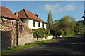
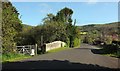
House, Cross
Riverton House is on the Old Coach Road at the south edge of Cross. On the right you can see the parapet of Bow Bridge over the Cheddar Yeo.
Image: © Derek Harper
Taken: 4 May 2016
0.01 miles
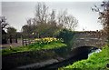
2
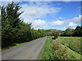
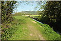
Old Coach Road, Cross
The road from Lower Weare approaches Bow Bridge across the Cheddar Yeo.
Image: © Derek Harper
Taken: 4 May 2016
0.03 miles
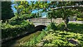
3
Cross Village near Axbridge
Bow Bridge
Image: © norman griffin
Taken: 22 Mar 2000
0.03 miles
5
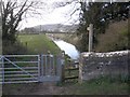
Bow Bridge, Cross
The old Coach Road from Lower Weare crosses the Cheddar Yeo.
Image: © Derek Harper
Taken: 4 May 2016
0.04 miles
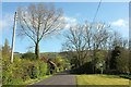
6
Old Coach Road
The Mendip Hills rising abruptly ahead.
Image: © Jonathan Thacker
Taken: 15 Sep 2015
0.04 miles
8
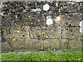
Benchmark on Bow Bridge
The OS description is BOW BR PARA E SIDE OLD COACH RD C STR, where C STR means 'centre of stream'.
Image: © Neville Goodman
Taken: 3 Jun 2017
0.04 miles
9
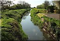
Cheddar Yeo
Looking downstream from Bow Bridge, a spring version of the late summer scene in Image The river is pointing directly at Nyland Hill. Footpath AX 15/18 follows Cross Moor Drove along the bank on the left, which of course is the right bank.
Image: © Derek Harper
Taken: 4 May 2016
0.05 miles
10
Cheddar Yeo
Looking downstream from Bow Bridge; more or less the view in Image Footpath AX 15/13 runs along the left bank. Crook Peak is in the backgriound.
Image: © Derek Harper
Taken: 4 May 2016
0.05 miles