IMAGES TAKEN NEAR TO
Hillside, AXBRIDGE, BS26 2AN
Introduction
This page details the photographs taken nearby to Hillside, BS26 2AN by members of the Geograph project.
The Geograph project started in 2005 with the aim of publishing, organising and preserving representative images for every square kilometre of Great Britain, Ireland and the Isle of Man.

There are currently over 7.5m images from over14,400 individuals and you can help contribute to the project by visiting https://www.geograph.org.uk
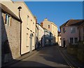
Image Map (Loading...)


Getting Data...Please wait
Leaflet Map data © OpenStreetMap
Images are licensed for reuse under creativecommons.org/licenses/by-sa/2.0
Notes
- Clicking on the map will re-center to the selected point.
- The higher the marker number, the further away the image location is from the centre of the postcode.
Image Listing (291 Images Found)
Images are licensed for reuse under creativecommons.org/licenses/by-sa/2.0
Image
Details
Distance
1
The Lamb public house, Axbridge, Somerset
Image: © Anthony O'Neil
Taken: 27 Sep 2009
0.06 miles
2
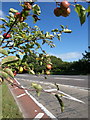
Apples by the Axbridge bypass
The slip road from the roundabout at the west end of Axbridge joins the A371, which is following the old railway line. Those apples look tempting, but it's not the best of healthy growing environments.
Image: © Derek Harper
Taken: 9 Aug 2011
0.07 miles
3
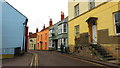
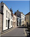
West Street, Axbridge
Alternate buildings on the left, each with a pediment over the door, are listed; Arundel House http://webapp1.somerset.gov.uk/her/details.asp?prn=13063 ; no 6 http://webapp1.somerset.gov.uk/her/details.asp?prn=13062 ; and the three-storey no 2 http://webapp1.somerset.gov.uk/her/details.asp?prn=13061 .
Image: © Derek Harper
Taken: 13 Nov 2005
0.07 miles
4
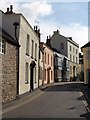
West Street, Axbridge
Taken in May rather than November as in Image (see for details of which houses are listed), with the relative height of the sun making a great difference.
Image: © Derek Harper
Taken: 24 May 2010
0.07 miles
5
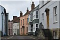
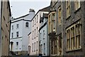
West Street, Axbridge
The view shown in Image in somewhat weaker sunshine. At the top of the hill, on the right and approached by steps, is number 2 Horn's Lane http://www.britishlistedbuildings.co.uk/en-268713-2-axbridge .
Image: © Derek Harper
Taken: 15 Aug 2011
0.07 miles
6

Choate House, Axbridge
The house (now divided into flats) stands at the junction of High Street and West Street, Axbridge. It is listed grade II
Image: © David Smith
Taken: 1 Oct 2021
0.07 miles
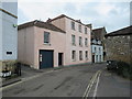
7
Looking towards the top of High Street, Axbridge
Image: © David Martin
Taken: 20 Feb 2023
0.08 miles
8
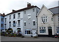
West Street and High Street, Axbridge
The end of West Street and the start of High Street in the village of Axbridge in Somerset.
This road is on the route of the Strawberry Line path and National Cycle Network route 26.
Image: © Malc McDonald
Taken: 23 Aug 2020
0.08 miles