IMAGES TAKEN NEAR TO
Church Lane, WINSCOMBE, BS25 5QW
Introduction
This page details the photographs taken nearby to Church Lane, BS25 5QW by members of the Geograph project.
The Geograph project started in 2005 with the aim of publishing, organising and preserving representative images for every square kilometre of Great Britain, Ireland and the Isle of Man.

There are currently over 7.5m images from over14,400 individuals and you can help contribute to the project by visiting https://www.geograph.org.uk
Image Map
Images are licensed for reuse under creativecommons.org/licenses/by-sa/2.0
Notes
- Clicking on the map will re-center to the selected point.
- The higher the marker number, the further away the image location is from the centre of the postcode.
Image Listing (44 Images Found)
Images are licensed for reuse under creativecommons.org/licenses/by-sa/2.0
Image
Details
Distance
1
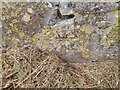
Ordnance Survey Cut Mark
This OS cut mark can be found on the wall west side of the road. It marks a point 34.787m above mean sea level.
Image: © Adrian Dust
Taken: 21 Aug 2022
0.01 miles
2
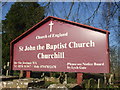
St John the Baptist entrance board
The last incumbent didn't appear to have a mobile - perhaps it's been a long tenure.
Image: © Neil Owen
Taken: 6 Feb 2020
0.01 miles
3
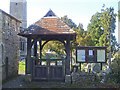
The lychgate of St John
Coupled with a handy notice board.
Image: © Neil Owen
Taken: 6 Feb 2020
0.01 miles
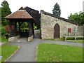
5
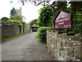
Entrance to Churchill Green church
Entrance to St John the Baptist Church at Churchill Green.
Image: © Philip Halling
Taken: 6 Jun 2016
0.02 miles
6
St John the Baptist in Churchill Green
The church bears a benchmark at the bottom of the drainpipe - see Image
Image: © Neil Owen
Taken: 6 Feb 2020
0.02 miles
7
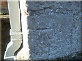
A mark on St John the Baptist church
A cutmark, as listed in the Benchmark Database: https://www.bench-marks.org.uk/bm74218 , on the church of Churchill Green. See Image] for a wider view.
Image: © Neil Owen
Taken: 6 Feb 2020
0.02 miles
8
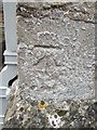
Ordnance Survey Cut Mark
This OS cut mark can be found on the east face of St John the Baptist's Church. It marks a point 33.869m above mean sea level.
Image: © Adrian Dust
Taken: 16 Mar 2016
0.02 miles
9
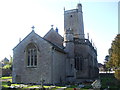
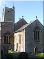
St John the Baptist, Churchill
The church has Norman roots in the nave (about 1180), and subsequently incorporated in later additions -chiefly around 1400. Naturally, some more modern parts are due to the ever-eager Victorians.
The church now stands in Churchill Green - a little distance from the heart of modern Churchill. It is suggested that the relocation of the villagers may have been down to worries over the Plague in times past.
Image: © Neil Owen
Taken: 6 Feb 2020
0.02 miles
10
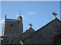
All pointing to heaven
St John the Baptist church rooflines have north-east polygonal higher corner stair turret with blind panelled embattled cap and pierced quatrefoil lozenge parapet with corner pinnacles and gargoyles.
Image: © Neil Owen
Taken: 6 Feb 2020
0.03 miles